
Schöpf, Thomas

Thomas Schöpf (1520 - June 16, 1577) was a Swiss physician, to whom was credited one of the most important regional maps of Switzerland to be produced in the 16th century, named the Schöpfkarte. He was educated at the University of Basel, then in Wittenberg, receiving a doctorate in 1547. He studied medicine in Basel and received a doctorate in medicine in 1553. He served as city physician in Colmar, and in 1564 was appointed city Physician in Bern. He died of the plague in 1577. Schöpf was long considered the author of a handwritten description of the Bern region, as well as a meticulously detailed wall map of the Bernese territory. Schöpf's authorship is contested. He was named as the author of a 1577 handwritten description of the region (from which the map may have been derived, or vice versa) archival research by Anne-Marie Dubler has suggested that the prominent physician Schöpf lent his name to the production of the map but that its actual author was Bernese politician and diplomat Niklaus Zurkinden (October 31, 1506 - September 20, 1588) Zurkinden's expertise and access to data certainly makes him in many respects a more credible creator than Schöpf, but the physician's role as a aegis for the project was so successful at obscuring Zurkinden's role in producing the map that it is difficult to make the case stick.
Earliest Detailed Mapping of the Bernese Alps.
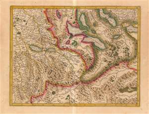
[Bernese Alps and the Swiss Lake District]
$450.00
Acquire
- Digital Map Information
- Suitable for large format printing
- DPI: 600
- File Size: 22.15 MB
- File Type: ZIP / TIFF
- ICC color profile embedded
- Delivered instantly via download link
This is Gerard Mercator's 1585 map of the Bernese Oberland and the Lake District of central Switzerland, in a warmly-colored Hondius edition. It is the earliest acquirable map to detail this specific region and is the earliest derivative of Thomas Schöpf's groundbreaking 1578 map of the Canton of Bern. It is the only acquirable early map of the Bernese Alps to name multiple peaks. (more details)