
Sheafer, Peter Wenrick

Peter Wenrick Sheafer (March 31, 1819 - March 26, 1891) created several celebrated maps of Pennsylvania. He was a civil and mining engineer from Pottsville, Pennsylvania. Sheafer was born in Dauphin County, PA and studied engineering in New York. In 1838 he assisted in making the first geological survey of Pennsylvania, trading the line of what was known as 'Second Mountain, the basin of the southern Anthracite coal fields. He settled in Pottsville, PA, center of the mining industry, in 1848. With state support, he continued his survey work in 1849 - publishing, with Robert P. Smith, an important large-scale map of the Anthracite Fields. His mapmaking career included a 1855 Map of Schuykill County, Pennsylvania. He also published the first version of his Official Coal, Iron, Railroad and Canal Map of Pennsylvania and C. in 1863, which was so popular that it was included in the state document Reports of the Several Railroad Companies of Pennsylvania Communicated by the Auditor General of the Legislature. Versions of this map were published until around 1870 in the Auditor General’s reports. Sheafer’s Historical Map of Pennsylvania was published in 1873 and subsequently republished by The Historical Society of Pennsylvania in 1875 with a 28 page booklet of information. Sheafer died at a heath spa in Brown's Mills, New Jersey, not far from Atlantic City.
Pennsylvania Anthracite Boom - driving the Industrial Revolution.
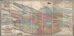
Map of the First and Second Anthracite Coal Fields in Pennsylvania; embracing Schuylkill County and parts of Carbon, Luzerne, Columbia, Northumberland, Dauphin and Lebanon Counties.
$3,500.00
Acquire
- Digital Map Information
- Suitable for large format printing
- DPI: 600
- File Size: 211.86 MB
- File Type: ZIP / TIFF
- ICC color profile embedded
- Delivered instantly via download link
This is a large-scale 1849 Peter W. Sheafer and Robert P. Smith map of northeastern Pennsylvania illustrating the peak of the Anthracite Coal Boom - one of the driving factors of American industrial development in the 19th century. (more details)