1849 Smith Wall Map of the Pennsylvania Anthracite Coal Fields
PennsylvaniaCoalFields-smith-1849$3,500.00


Title
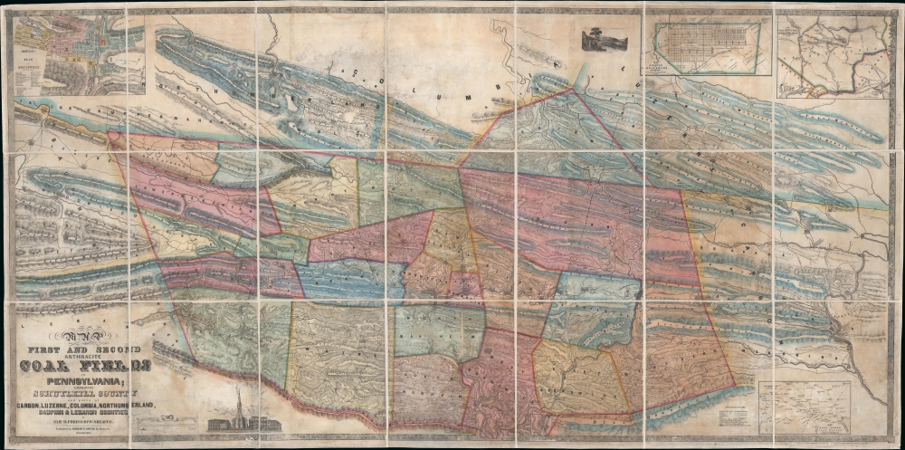
Map of the First and Second Anthracite Coal Fields in Pennsylvania; embracing Schuylkill County and parts of Carbon, Luzerne, Columbia, Northumberland, Dauphin and Lebanon Counties.
1849 (dated) 39 x 78.5 in (99.06 x 199.39 cm) 1 : 42200
1849 (dated) 39 x 78.5 in (99.06 x 199.39 cm) 1 : 42200
Description
This is a large-scale 1849 Peter W. Sheafer and Robert P. Smith map of northeastern Pennsylvania illustrating the peak of the Anthracite Coal Boom - one of the driving factors of American industrial development in the 19th century.
There is an inset of Pottsville - Pennsylvania's Coal Capital - and the regional rail hub. (Incidentally, Pottsville is where the Irish laborer secret society, the Molly Maguires, battled against unfair labor practices in the 1870s.) Another inset focuses on Orwigsburg, the Schuylkill County Seat when this map was made and until 1851, when it moved to Pottsville. A third inset details post towns and routes around Pottsville. A fourth, in the upper right, illustrates railway connections with major industrial hubs, including New York, Baltimore, and Philadelphia. An engraved vignette illustrates Mauch Chunk, today's Jim Thorpe.
A Closer Look
This 1849 map is based on an earlier 1836 map published by Fischer and the firm of J. F. and C. A. Watson - upon which it expands and elaborates. Centered on Pottsville and oriented slightly to the northwest, coverage embraces a broad swath of northeastern Pennsylvania, comprising the primary coal-producing regions: Schuylkill, Carbon, Luzerne, Columbia, Northumberland, Dauphin, and Lebanon counties. The large scale allows for the detailed illustration of individual mountains, estates, coal company lands, railroads, small streams, and town grids.There is an inset of Pottsville - Pennsylvania's Coal Capital - and the regional rail hub. (Incidentally, Pottsville is where the Irish laborer secret society, the Molly Maguires, battled against unfair labor practices in the 1870s.) Another inset focuses on Orwigsburg, the Schuylkill County Seat when this map was made and until 1851, when it moved to Pottsville. A third inset details post towns and routes around Pottsville. A fourth, in the upper right, illustrates railway connections with major industrial hubs, including New York, Baltimore, and Philadelphia. An engraved vignette illustrates Mauch Chunk, today's Jim Thorpe.
Pennsylvania Anthracite Coal Boom
The Pennsylvania anthracite coal boom in the 19th century marked a transformative period in the state's economic, social, and environmental history. Anthracite, a hard coal known for its high energy content and low impurities, became highly sought after as a fuel source during the Industrial Revolution. This coal, found primarily in northeastern Pennsylvania, was uniquely suited for industrial processes and home heating without the heavy smoke common to other coal types. As demand skyrocketed, towns sprang up around mines, drawing thousands in search of employment. The industry catalyzed the construction of extensive rail networks, facilitating the transport of coal to major cities and ports. However, with the boom came significant challenges: mining led to environmental degradation, miners worked in dangerous conditions for meager wages, and tensions between labor and management frequently erupted in strikes and violence. Despite its challenges, the anthracite coal boom was a linchpin in America's industrial ascent.Publication History and Census
The map was compiled by Samuel B. Fisher and P. W. Sheafer. It was published in 1849 in Philadelphia by Robert Pearsall Smith. This map is rare. We note examples only at the New York Public Library and the University of Wisconsin - Milwaukee. No history on the market.CartographerS
Robert Pearsall Smith (February 1, 1827 - April 17, 1898) was an American map maker active in Philadelphia from the middle to late 19th century. Smith was born to a Quaker family in Philadelphia, all librarians and publishers. Robert Pearsall originally ran a law bookstore at 19 James Street, Philadelphia. It was not until 1846 that Smith began producing maps in collaboration with this father, John Jay Smith, and brother, Lloyd P. Smith. One year earlier, in 1845, John Jay, then librarian at the Library Company of Philadelphia and Loganian Library, acquired the American rights to the anastatic process of transfer lithography. In February of 1846 he and his two sons founded the Anastatic Office, a printing concern based on the anastatic process located at 317 Market Street, Philadelphia. The Anastatic Office produced numerous copies and reissues of historic documents and maps from the Library Company's collection before being dissolved in 1847. In the same year Robert Pearsall opened a printing establishment under his own name at 144 Chestnut Street. In 1858, he joined forced with the Swiss-American engraver Frederick Bourquin (1808 - 1897) under the imprint 'F. Bourquin and Company' (602 Chestnut Street). Smith retired suddenly and inexplicably from the printing business around 1865. Smith was also deeply religious, a lay leader in the Holiness Movement in the United States and the Higher Life Movement in Great Britain. Smith and his wife, Hannah Tatum Whitall, first crossed the Atlantic to preach in England, Germany and Switzerland in 1873. They returned in 1875, preaching in Brighton, where Smith supposedly had an affair with an American writer. In, 1888, his entire family moved to England. More by this mapmaker...
Peter Wenrick Sheafer (March 31, 1819 - March 26, 1891) created several celebrated maps of Pennsylvania. He was a civil and mining engineer from Pottsville, Pennsylvania. Sheafer was born in Dauphin County, PA and studied engineering in New York. In 1838 he assisted in making the first geological survey of Pennsylvania, trading the line of what was known as 'Second Mountain, the basin of the southern Anthracite coal fields. He settled in Pottsville, PA, center of the mining industry, in 1848. With state support, he continued his survey work in 1849 - publishing, with Robert P. Smith, an important large-scale map of the Anthracite Fields. His mapmaking career included a 1855 Map of Schuykill County, Pennsylvania. He also published the first version of his Official Coal, Iron, Railroad and Canal Map of Pennsylvania and C. in 1863, which was so popular that it was included in the state document Reports of the Several Railroad Companies of Pennsylvania Communicated by the Auditor General of the Legislature. Versions of this map were published until around 1870 in the Auditor General’s reports. Sheafer’s Historical Map of Pennsylvania was published in 1873 and subsequently republished by The Historical Society of Pennsylvania in 1875 with a 28 page booklet of information. Sheafer died at a heath spa in Brown's Mills, New Jersey, not far from Atlantic City. Learn More...
Condition
Good. Professionally restored and relined on fresh linen. Some discolorations. Comes with newly made binder.
References
OCLC 46794663. New York Public Library, Map Div. 01-1948.