
Spofford, Edward Wiltsie

Edward Wiltsie Spofford (August 29, 1863 - January 4, 1946) was an American commercial artist. He was born in Groveland, Massachusetts, in 1863. We have no record of his early education, but he appears as an engraver in Boston directories as early as 1883. He lived for a time in Chicago, but was active in New York from at least 1909, when he issued a series of views of Manhattan as seen from the deck of the Singer Tower. Spofford is noteworthy for developing a unique style of realistic high-perspective aerial view, which he called the 'supervue', likely based on the development of aerial photography in the early 20th century. His earliest view is a series of 1909 views of Manhattan as seen from the Singer Tower. Around this time, he also produced a view of Baltimore. He is best known for his 'Supervue of Manhattan', which enjoyed wide circulation in many formats from 1932 to the 1950s. His son, Edward V. Spofford (June 1894 - May 21, 1940) was also a commercial artist and may have collaborated with is father until his untimely 1940 death from a sudden cerebral hemorrhage.
Tallest building the World - in 1909.
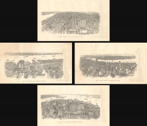
North View from the Singer Tower. / South View from the Singer Tower. / East View from the Singer Tower. / West View from the Singer Tower.
$1,200.00
Acquire
- Digital Map Information
- Suitable for large format printing
- File Size: 103.55 MB
- File Type: ZIP / TIFF
- ICC color profile embedded
- Delivered instantly via download link
This is a rare set of four 1909 Edward Spofford views of Manhattan, New York, as seen from the deck of the Singer Tower. This view was issued at the dawn of the Skyscraper Age when the Singer Tower (1908 - 1968) was the world's tallest building. Thus, Spofford's views, commissioned by the Singer Company, were novel to most New Yorkers, who could have never imagined seeing their city from such a lofty perspective. It is also Spofford's earliest known work. They are a stunning celebration of one of New York's long-lost architectural wonders, a casualty of 'modernization' in the 1960s. (more details)
Down of the Skyscraper Age.
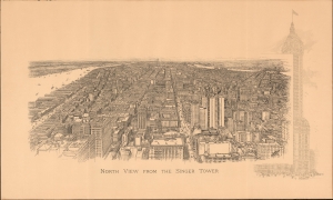
North View from the Singer Towner.
$1,100.00
Acquire
- Digital Map Information
- Suitable for large format printing
- File Size: 21.62 MB
- File Type: ZIP / TIFF
- ICC color profile embedded
- Delivered instantly via download link
This is a dramatic 1909 Edward W. Spofford view of New York City celebrating the opening of the Singer Tower. The Singer town was worthy of such a view, for this kind of high oblique perspective would have been a novelty to most New Yorkers as the newly finished Singer Tower was, at the time, the world's tallest skyscraper, New York's most innovative building, and a Beaux-Arts design wonder. (more details)
Birth of the High Line.
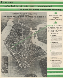
Map of New York City showing the location of the Port Authority Commerce Building.
$700.00
Acquire
- Digital Map Information
- Suitable for large format printing
- Full resolution TIFF file
- ICC color profile embedded
- Delivered instantly via download link
This is a 1932 Spofford and Freedman Supervue of New York City published by the Port Authority of New York to promote the newly-opened Port Authority Commerce Building. It is the earliest presentation of Spofford's iconic super view we have identified. The Supervue occupies 3/4 of the recto, and information about the Commerce Building occupies the rest of the recto and the entire verso. (more details)
Iconic Depression Era New York City view.
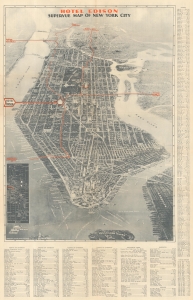
Hotel Edison SuperVue Map of New York City.
$450.00
Acquire
- Digital Map Information
- Suitable for large format printing
- Full resolution TIFF file
- ICC color profile embedded
- Delivered instantly via download link
This is a spectacular 1933 edition of the Edward V. Spofford / Samuel Freedman bird's-eye 'Supervue' map of New York City published to promote the Hotel Edison. Despite being issued at the height of the Great Depression, this view highlights New York City's resilience, prosperity, and multicultural dynamism. (more details)
Robert Moses' signature project.
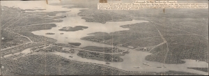
Triborough Bridge Authority Projects.
$950.00
Acquire
- Digital Map Information
- Suitable for large format printing
- File Size: 47.29 MB
- File Type: ZIP / TIFF
- ICC color profile embedded
- Delivered instantly via download link
This is Edward Spofford's bird's-eye view of the Triborough Bridge and connections, New York City. The map was issued at the peak of Robert Moses' controversial efforts to build highways connecting New York's boroughs, Long Island, and Westchester. (more details)
Go visit the New York World's Fair!
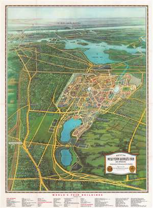
Map of the New York World's Fair and Approaches.
$350.00
Acquire
- Digital Map Information
- Suitable for large format printing
- Full resolution TIFF file
- ICC color profile embedded
- Delivered instantly via download link
This is a 1939 Edward V. Spofford bird's-eye view map of the 1939 New York World's Fair. Overlooking the fair from a fictional highpoint to the east, many of the fair's buildings are illustrated. The famous Trylon and Perisphere are immediately recognizable. 'Streets' throughout the fairground are identified, along with Constitution Mall and several 'courts'. Subway stations, bus parking areas, and the Long Island Rail Road station are also labeled. Outside the World's Fair, main thoroughfares and subway lines recognizable in Queens, the Bronx, and Manhattan as far south as 34th Street and the Empire State Building. The Queens Midtown Tunnel is labeled as being under construction. Central Park, Rockefeller Center, and the Lincoln Tunnel are also identified. (more details)