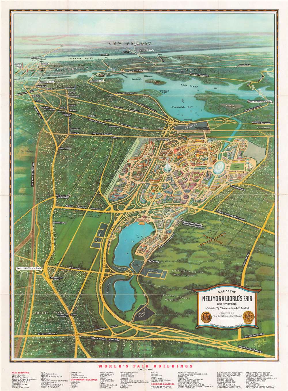
1939 Spofford Bird's-Eye View Map of the New York World's Fair
NYWorldsFair-spofford-1939$350.00

Title
Map of the New York World's Fair and Approaches.
1939 (dated) 24.25 x 17.5 in (61.595 x 44.45 cm)
1939 (dated) 24.25 x 17.5 in (61.595 x 44.45 cm)
Description
This is a 1939 Edward V. Spofford bird's-eye view map of the 1939 New York World's Fair. Overlooking the fair from a fictional highpoint to the east, many of the fair's buildings are illustrated. The famous Trylon and Perisphere are immediately recognizable. 'Streets' throughout the fairground are identified, along with Constitution Mall and several 'courts'. Subway stations, bus parking areas, and the Long Island Rail Road station are also labeled. Outside the World's Fair, main thoroughfares and subway lines recognizable in Queens, the Bronx, and Manhattan as far south as 34th Street and the Empire State Building. The Queens Midtown Tunnel is labeled as being under construction. Central Park, Rockefeller Center, and the Lincoln Tunnel are also identified.
Verso Content
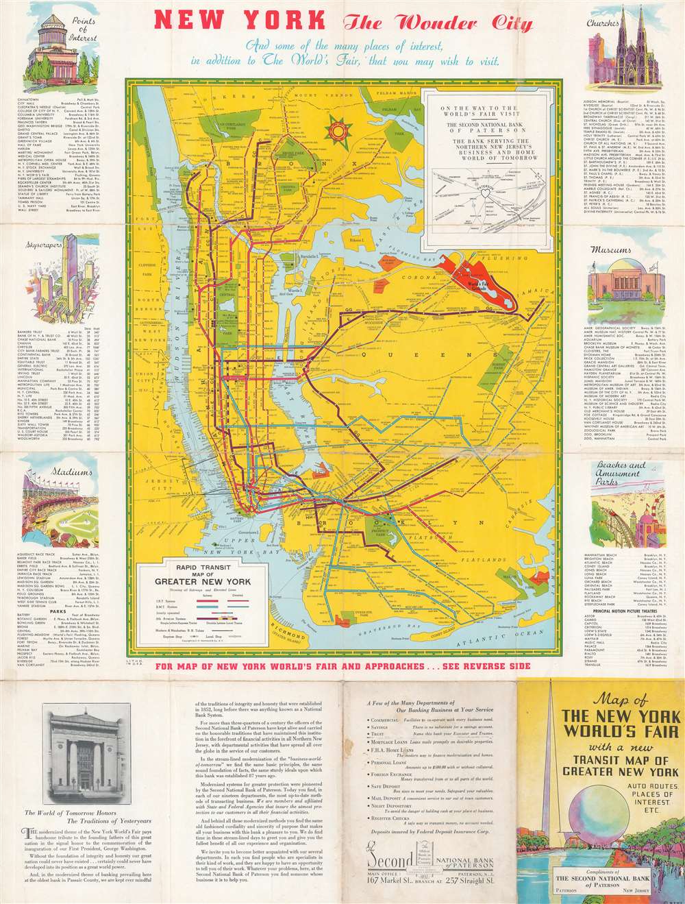
A map of the New York Subway occupies three-quarters of the verso. The B.M.T. and the I.R.T. are differentiated and elevated and subterranean lines are separated out. An index split between the left and right borders lists museums, skyscrapers, stadiums, churches, beaches, amusement parks, and other points of interest. An advertisement for Second National Bank of Paterson in Paterson, New Jersey occupies the bottom quarter of the sheet. The map was provided compliments of the bank. Likely, this section of the map was reserved to promote any business that paid to distribute copies of the map before and during the fair.The 1939 - 1940 New York World's Fair
The 1939 - 1940 New York World's Fair took place in Queens at Flushing Meadows - Corona Park. During its two exhibition seasons, over forty-four million people attended. It was also the second most expensive World's Fair in the United States, behind the 1904 Louisiana Purchase Exposition in St. Louis, Missouri. World War II began four months after the fair opened and many of the displays were affected, particularly those pavilions of countries under Axis occupation. After the fair closed in 1940, many of the European staff were unable to return home, so they stayed in the United States.Publication History and Census
This map was drawn by Edward V. Spofford and published by C.S. Hammond and Company in 1939. It is well represented in institutional collections but scarce on the market.CartographerS
Edward Wiltsie Spofford (August 29, 1863 - January 4, 1946) was an American commercial artist. He was born in Groveland, Massachusetts, in 1863. We have no record of his early education, but he appears as an engraver in Boston directories as early as 1883. He lived for a time in Chicago, but was active in New York from at least 1909, when he issued a series of views of Manhattan as seen from the deck of the Singer Tower. Spofford is noteworthy for developing a unique style of realistic high-perspective aerial view, which he called the 'supervue', likely based on the development of aerial photography in the early 20th century. His earliest view is a series of 1909 views of Manhattan as seen from the Singer Tower. Around this time, he also produced a view of Baltimore. He is best known for his 'Supervue of Manhattan', which enjoyed wide circulation in many formats from 1932 to the 1950s. His son, Edward V. Spofford (June 1894 - May 21, 1940) was also a commercial artist and may have collaborated with is father until his untimely 1940 death from a sudden cerebral hemorrhage. More by this mapmaker...
Caleb Stillson Hammond (1862 - 1929) was the founder of C. S. Hammond & Company, a map making and printing firm based in Brooklyn, New York. Hammond started his career in mapmaking as the head of Rand McNally's offices in New York City, where he began working in 1894. Hammond split with Rand McNally, forming his own printing concern in Brooklyn, New York, in 1900. The firm was subsequently incorporated in 1901 and relocated to Manhattan, and then to Maplewood, New Jersey, near Hammond's family home. Hammond rose to become one of the largest cartographic publishers in the United States, second only to Rand McNally in volume. On his retirement, C. S. Hammond passed the firm to his son, who subsequently passed it to his own son, C. D. Hammond, who sold the company to Langenscheidt Publishers in 1999. The firm has since been folded into Universal Map, an affiliate of Kappa Publishing Group. This archives of the Hammond World Atlas Corporation, an invaluable resource, where donated to the Library of Congress in 2002. Learn More...
Condition
Good. Exhibits wear along original fold lines. Verso repairs to fold separations. Exhibits minor loss at some fold intersections. Map of New York City Subway and supplemental text printed on verso.
References
Rumsey 8806.003. OCLC 1243880975.