
Spofforth, Robert

Robert Spofforth (fl. 1700 - 1707) was an English engraver and printseller known primarily for his frontispieces. He contributed nine engravings to Edward Wells’ A New Sett of Maps both of Ancient and Present Geography, including the frontispiece of the atlas. He was thought to have been a student of the engraver Simon Gribelin. He was also known for his portraits, namely those of Queen Anne and Prince George.
Mr. Moses' Bridges - Both Real and Imagined.
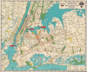
Sign marked Routes to the Triborough and Bronx-Whitestone Bridges / Triborough Bridge Authority Traffic Crossings Linking the Boroughs of Manhattan, Bronx and Queens.
$450.00
Acquire
- Digital Map Information
- Suitable for large format printing
- Full resolution TIFF file
- ICC color profile embedded
- Delivered instantly via download link
This engrossing c. 1939 folding map of New York City was prepared by local cartographic firm Hagstrom for the Triborough Bridge Authority. Meant primarily to inform motorists, it also serves as a celebration of the vision of urban planner and highway enthusiast Robert Moses. At the same time, the map chronicles one of Moses' rare defeats, the never-built 'Battery-Brooklyn Bridge.' (more details)