
Spofforth, Robert (sold)

Robert Spofforth (fl. 1700 - 1707) was an English engraver and printseller known primarily for his frontispieces. He contributed nine engravings to Edward Wells’ A New Sett of Maps both of Ancient and Present Geography, including the frontispiece of the atlas. He was thought to have been a student of the engraver Simon Gribelin. He was also known for his portraits, namely those of Queen Anne and Prince George.
Beautiful 18th century map of Spain and Portugal.
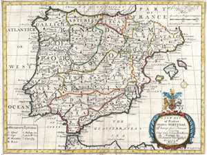
A New Map of Spain and Portugal. Showing their Principal Divisions, Chief Cities, Townes, Ports, Rivers, Mountains, etc.
sold
- Digital Map Information
- Suitable for large format printing
- DPI: 300
- File Size: 7.7 MB
- File Type: ZIP / TIFF
- ICC color profile embedded
- Delivered instantly via download link
This is a 1700 Edward Wells map of Spain and Portugal. The map depicts the Iberian Peninsula, where both Spain and Portugal and located, from the Bay of Biscay on the top to Morocco on the bottom and from the Atlantic Ocean on the left to the Mediterranean Sea on ... (more details)
The Fertile Crescent Mapped.
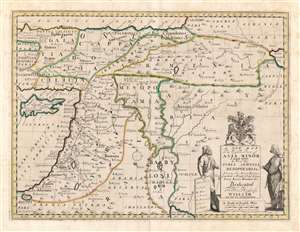
A New Map of the Eastern Parts of Asia Minor Largely taken: As Also of Syria, Armenia, Mesopotamia and c. Shewing their Antient Divisions, Countries or People, Chiefe Cities, Towns, Rivers, Mountains etc. Dedicated to His Highness William Duke of Gloucester.
sold
- Digital Map Information
- Suitable for large format printing
- DPI: 600
- File Size: 46.39 MB
- File Type: ZIP / TIFF
- ICC color profile embedded
- Delivered instantly via download link
This is an elegant 1700 Edward Wells map of the eastern Mediterranean and ancient Mesopotamia. Coverage extends from Cyprus and Asia Minor, eastwards as far as the Caspian and Persian Gulf. The central focus is the watershed of the Tigris and Euphrates, thus embracing ancient Mesopotamia and Babylonia. The kingdoms of Assyria, Armenia, Palestine and Syria are prominent. A decorative title cartouche appears in the lower right, surmounted by the arms of the dedicatee - Prince William, Duke of Gloucester and the son of Queen Anne, who, when this map was being prepared, was a student of Wells. The sickly William never lived to see his tutor's work completed. (more details)