
Thornton, Samuel

Samuel Thornton (1665 - October, 1715) was an English map publisher active in the late 17th and early 18th centuries. Samuel was the son of John Thornton (1641 - 1708), the second major publisher of the English Pilot. Samuel inherited his father's business and the English Pilot plates in 1708, publishing revised edition of the English Pilot, The Third Book in 1711, and The English Pilot, the Fourth Book. Describing the West-Indian Navigation in 1713. Like his father, Thornton enjoyed a mandate from the British East Indian Company and was their primary chart provider. His name is attached to several charts of the India coast that he added to the English Pilot, The Third Book, 1703. When he died, publication of the English Pilot was taken over by Richard Mount and Thomas Page. They, unlike their predecessors, were not mandated by the British East India Company.
Earliest Printed, Accurate Chart of the Source of London's Coffee.
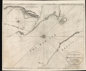
A Chart of the Straits of Babelmandell and Moha.
$2,000.00
Acquire
- Digital Map Information
- Suitable for large format printing
- Full resolution TIFF file
- ICC color profile embedded
- Delivered instantly via download link
This is John and Samuel Thornton's scarce c. 1703/1707 chart of Bab el Mandab, the Strait of Mandeb, or 'the Gate of Lamentation.' For centuries, this has represented a chokepoint between the Arabian Peninsula and the Horn of Africa and also forms a strategic bottleneck between the Red Sea and the Gulf of Aden. The present chart is the first of the Strait to benefit from a firsthand survey at a time when this region supplied most of Europe's coffee. (more details)
Censored Map: One of the first specific printed maps of the Gulf of Thailand and Cambodia.
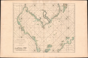
Carte plate qui comprend le Golfe de Siam, les costes de Cambodia, de Tsiompa et les Isles adjacentes, avec une partie de l'Isle Bornéo.
$2,300.00
Acquire
- Digital Map Information
- Suitable for large format printing
- Full resolution TIFF file
- ICC color profile embedded
- Delivered instantly via download link
This is a rare 1745 d'Après de Mannevillette nautical chart or maritime map of the South China Sea and the Gulf of Thailand. It is one of the first specific printed maps of the Gulf of Thailand and Cambodia. This map, and others from the 1745 edition of Mannevillette, were censured by the French Admiralty, and mostly destroyed - making them both exceedingly rare and poorly understood. (more details)