1745 Mannevillette Map of the Gulf of Siam, Cambodia, Vietnam
GulfSiamCambodia-mannevillette-1745$2,300.00


Title
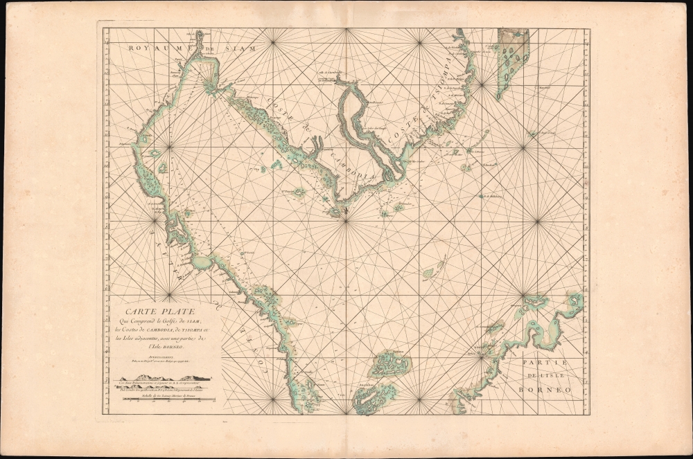
Carte plate qui comprend le Golfe de Siam, les costes de Cambodia, de Tsiompa et les Isles adjacentes, avec une partie de l'Isle Bornéo.
1745 (undated) 25 x 38 in (63.5 x 96.52 cm) 1 : 2584000
1745 (undated) 25 x 38 in (63.5 x 96.52 cm) 1 : 2584000
Description
This is a rare 1745 d'Après de Mannevillette nautical chart or maritime map of the South China Sea and the Gulf of Thailand. It is one of the first specific printed maps of the Gulf of Thailand and Cambodia. This map, and others from the 1745 edition of Mannevillette, were censured by the French Admiralty, and mostly destroyed - making them both exceedingly rare and poorly understood.
Thornton doubtless copied old Dutch charts compiled after 1635, when they took over the Cambodia trade formerly dominated by Japan. One such V.O.C. manuscript appeared at Christies in 1999, and may well be the source of both Thornton and the present map. There we see, for the first time, the general outline of the coasts, the large island clusters east of Malaya representing the Riau Archipelago, and the primitive mapping of both the Mekong and the Chao Phraya as far as Ayutthaya (Siam) - note this same cartography appears on François Valentijn's (1666 - 1727) map of the Kingdom of Siam. The mapping of the Paracel Islands as a large, squared wedge in the upper right, as well as other details, was added in the Thornton manuscript.
A Closer Look
Coverage extends from western Malaya just north of Singapore to the ancient Siamese (Thailand) capital at Ayutthaya, to the Paracel Islands just east of Vietnam, and south to northern Borneo. The map focuses on the Mekong north to 'Ville de Cambodia', roughly modern-day Phenom Penh, and the surrounding seas.Primary Sources
Cartographically, this map is attributed to the 'Anciennes Cartes', by which Mannevillette is referring most directly to John Thornton's (1641 - 1708) 1701 manuscript map of the same region - which this map follows in terms of scope, scale, and detail. There are multiple updates, a signature feature of Mannevillette's maps, as he not only collected charts, but corrected and revised them from firsthand observations. The original Thornton manuscript is preserved at the Bibliothèque nationale de France (CPL GE SH ARCH-29).Thornton doubtless copied old Dutch charts compiled after 1635, when they took over the Cambodia trade formerly dominated by Japan. One such V.O.C. manuscript appeared at Christies in 1999, and may well be the source of both Thornton and the present map. There we see, for the first time, the general outline of the coasts, the large island clusters east of Malaya representing the Riau Archipelago, and the primitive mapping of both the Mekong and the Chao Phraya as far as Ayutthaya (Siam) - note this same cartography appears on François Valentijn's (1666 - 1727) map of the Kingdom of Siam. The mapping of the Paracel Islands as a large, squared wedge in the upper right, as well as other details, was added in the Thornton manuscript.
Vestiges of Trade
Thornton's 1701 chart was copied from Dutch V.O.C. manuscript maps prepared in Batavia in the mid to late 17th-century. These jealously guarded charts began to appear after 1635. Before 1635, the Japanese dominated trade with Cambodia and fiercely defended their routes. In 1635, the Sakoku Edict (Sakoku-rei, 鎖国令) came into effect, creating the 'closed country' policy and ending all Japanese foreign trade. The Dutch, operating from Batavia, were quick to fill the trade vacuum. Nonetheless, legacies of the Japanese trade are preserved here. The Mekong, the primary Japanese trade artery with Phenom Penh (Ville de Cambodia), is identified as the R. Japanese. Also noted is the 17th-century Dutch lodge near Phenom Penh, which was long abandoned by this time, and another fort near Bangkok, apparently active.Publication History and Census
This map was published by Jean-Baptiste Nicolas Denis d'Après de Mannevillette in the scarce 1745 first edition of his maritime atlas, Le Neptune Oriental. Most examples of the 1745 Le Neptune Oriental were destroyed by the French Admiralty, who considered the information contained within too comprehensive, and thus dangerous to French interests. This map was not included in the relatively common 1775 second edition of Mannevillette's atlas, so today is extremely rare. We note just two other examples, both grossly misdated and held at the Bibliothèque nationale de France, one in the Collection d'Anville (07110 B). No market history.CartographerS
Jean-Baptiste Nicolas Denis d'Après de Mannevillette (February 11, 1707 - March 1, 1780) was a French sailor, navigator, and hydrographer active in the mid-18th century. Mannevillette was born in Le Havre to a family of wealthy seafarers. He completed his first major voyage at 12, when he accompanied his father, Jean-Baptiste-Claude d'Après de Blangy, a captain of the Compagnie des Indes (French East India Company) vessel Solide to Bengal. On his return to France, he he studied mathematics and navigation in Paris under Joseph Nicholas De L'Isle (1688 - 1768) before returning to the sea at 19 as a fourth officer as on the merchant vessel Marechel d'Estrees. Mannevillette himself eventually attained the rank of Captain with the Compagnie des Indes. In the course of numerous voyages around Africa to India and China, Mannevillette collected and revised numerous nautical charts. His sophisticated use of the most modern instruments, most specifically the Octant or English Quarter, and keen mathematical mind, enabled Mannevillette to correct many significant errors common to earlier maps. These updates were eventually compiled and published in Mannevillette's most significant work, the 1745 Le Neptune Oriental. The 1745 Neptune Oriental was commissioned by the Compagnie des Indes and its production earned Mannevillette admission into the Academy of Sciences. The atlas was well received, but shortly after publication, most unsold examples were destroyed by the French Admiralty, who considered the secrets of East Indian navigation too dangerous for dissemination. In 1762 the Compagnie des Indes appointed Mannevillette director of chart at Lorient. In 1767 King Louis XV conferred the Order of St. Michael upon him and made him an associate of the Royal Marine Academy. In the 30 years following his first publication of Le Neptune Oriental, Mannevillette worked doggedly with his lifelong friend, Alexander Dalrymple (1737 - 1808) to update his original work with new and improved charts. In 1775, he republished his opus in a greatly expanded format - by this time nautical information was less tightly guarded. Mannevillette died on March 1, 1780 at 75 years of age. More by this mapmaker...
Samuel Thornton (1665 - October, 1715) was an English map publisher active in the late 17th and early 18th centuries. Samuel was the son of John Thornton (1641 - 1708), the second major publisher of the English Pilot. Samuel inherited his father's business and the English Pilot plates in 1708, publishing revised edition of the English Pilot, The Third Book in 1711, and The English Pilot, the Fourth Book. Describing the West-Indian Navigation in 1713. Like his father, Thornton enjoyed a mandate from the British East Indian Company and was their primary chart provider. His name is attached to several charts of the India coast that he added to the English Pilot, The Third Book, 1703. When he died, publication of the English Pilot was taken over by Richard Mount and Thomas Page. They, unlike their predecessors, were not mandated by the British East India Company. Learn More...
Source
Mannevillette, Jean-Baptiste d'Apres de, Le Neptune Oriental, ou Routier Général des Côtes des Indes Orientales et de la Chine, (Paris) 1745.
Le Neptune Oriental was a large-scale maritime atlas first issued in 1745 by Jean-Baptiste Nicolas Denis d'Après de Mannevillette, a wealthy French sailor and hydrographer. From his first voyage as an adult in 1726, Mannevillette collected, revised, and created new nautical charts. These he published 20 years later in the first edition of Le Neptune Oriental, an important work issued for the Compagnie des Indes (French East India Company), for whom Mannevillette was a captain. The first edition of Le Neptune Oriental containing 25 charts, was received and earned him accolade on both navigational and scientific circles. Nonetheless, according to Manonmani Filliozat, writing in the Indian Journal of the History of Science,
The French Admiralty considering that the Neptune Oriental was too dangerous ... ordered the remaining copies to be destroyed. (#292, 1994, p. 341)This accounts somewhat for the extreme scarcity of the first edition and all of the maps contained therein. We also note a supportive comment in a, 1763 catalog of maps and charts issued by the French chart and map dealer Roch-Joseph Julien (1745 - 1779). Mannevillette nonetheless continued to collect and revise charts for the next 30 years, often working with the important English cartographer Alexander Dalrymple (1737 - 1808). In 1775, he issued greatly expanded and updated second edition of Le Neptune Oriental. This time with an additional 41 charts, making a total of 63 charts. This edition also proved popular and was widely disseminated. As noted by multiple cartobibliographers, there are variations between examples and no two seem to be identical, suggesting that many were compiled to order, often with additional maps that could be purchased but which were not in the standard collation. The second edition was published in Paris by Demonville and in Brest by Malassis. In 1781, one year after Mannevillette's, another work, Supplement au Neptune Oriental was issued, also by Demonville and Malassis.
Condition
Very good. Slight foxing. Even toning.
References
OCLC 495091911. Bibliothèque nationale de France, département Cartes et plans, CPL GE DD-2987 (7110 B).