
Keulen, Johannes II van

Johannes II van Keulen (1704 - 1755) was a Dutch map publisher, engraver, chartmaker, and instrument seller active in Amsterdam in the first half of the 19th century. He is a scion of the significant van Keulen publishing dynasty and, after his grandfather of the same name (1654 - 1715), the most important figure in that family's long publishing history. Johannes II's father was Gerard van Keulen (1678 - 1726). Like his father and grandfather, Johannes II was appointed hydrographer to the VOC (Vereenigde Oostindische Compagnie / United Dutch East India Company), inheriting the position on his father's 1726 death. He was elevated to chief VOC cartographer in 1743. In the next year, 1744, Jan Harmenszoon de Marre (1696 - 1763), Examiner of the Amsterdam Chamber of the VOC, was ordered to work with Johannes II to compile a new volume of the trademark van Keulen Zee-Fakkel, based upon manuscript nautical charts of the East Indies and East Asia long kept secret by the VOC. This work, published in 1753 as volume 6 of the Zee-Fakkel, was the first printing of the VOC's most tightly guarded secrets. The work was not intended for public sale, rather, it was meant to consolidate and improve upon the older, often contradictory, VOC manuscript charts. It became known as the 'Secret Atlas', as its use was restricted to VOC pilots who were issued the volume at the outset of a voyage, and expected to surrender it on the return. Although any VOC official, including van Keulen, with access to the atlas was placed under bonds of secrecy, data did eventually leak. Many of the maps, superior to anything previously obtainable, laid the foundation for subsequent charts published by English, French, and other Dutch cartographers. When Johannes II died, the business passed to his son, Gerard Hulst van Keulen (1733 - 1801).
First printed map to show Hong Kong in any form.
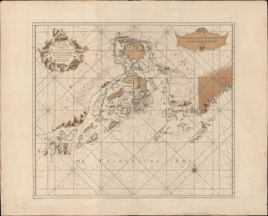
Pas-Kaart van het in en opkomen van de Rivier van Quantong aan de Zuid Kust van China strekkende van het eiland S. Joan, tot aan de Noorder Lemes, met alle tot hiertoe bekende ankerplaatzen, dieptens en droogtens.
$18,000.00
Acquire
- Digital Map Information
- Suitable for large format printing
- DPI: 600
- File Size: 828.08 MB
- File Type: ZIP / TIFF
- ICC color profile embedded
- Delivered instantly via download link
The rare 1753 Johannes II van Keulen / Jan de Marre nautical map of the Pearl River Delta (廣東河口海圖), including Macau (Macao), Lantao (Lantoan), Guangzhou (Quantong), and the first printed mapping of Hong Kong (Lantaon Falso). This rare map in fine original color was compiled for the sixth volume of the Zee-Fakkel - the legendary Dutch East India Company (VOC / Vereenigde Oostindische Compagnie) 'Secret Atlas.' (more details)