1753 Van Keulen 'Secret Atlas' Map of Hong Kong, Guangzhou, Pearl River, Macao, China
Quantong-vankeulen-1753$18,000.00
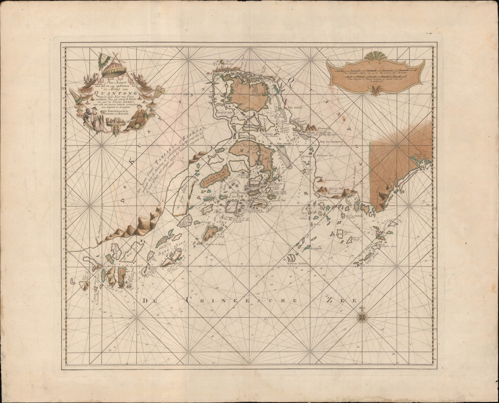

Title
Pas-Kaart van het in en opkomen van de Rivier van Quantong aan de Zuid Kust van China strekkende van het eiland S. Joan, tot aan de Noorder Lemes, met alle tot hiertoe bekende ankerplaatzen, dieptens en droogtens.
1753 (undated) 21 x 24 in (53.34 x 60.96 cm) 1 : 600000
1753 (undated) 21 x 24 in (53.34 x 60.96 cm) 1 : 600000
Description
The rare 1753 Johannes II van Keulen / Jan de Marre nautical map of the Pearl River Delta (廣東河口海圖), including Macau (Macao), Lantao (Lantoan), Guangzhou (Quantong), and the first printed mapping of Hong Kong (Lantaon Falso). This rare map in fine original color was compiled for the sixth volume of the Zee-Fakkel - the legendary Dutch East India Company (VOC / Vereenigde Oostindische Compagnie) 'Secret Atlas.'
This was likely an attempt to consolidate and improve the general hydrography. Previously, VOC charts in manuscript were disseminated to ship captains on an as-needed basis, to be returned upon a voyage's completion. A study of several VOC manuscript charts issued between 1720 and 1760 reveal striking disparities, likely resulting either from the charts being updated or copied from earlier less accurate charts. These differences led to avoidable navigational errors and the accompanying trade risks. A printed nautical atlas, whose hydrography was built upon the most up-to-date charts reassessed by the greatest chartmaker of the age, was a natural solution.
The new atlas was designed from VOC manuscript material collated and reassessed by Jan de Marre and van Keulen. Ostensibly it was an extension (Volume VI) of the existing commercially issued Nieuwe Lichtende Zee-Fakkel. However, it was intended only for VOC use, and thus became known as the 'Secret Atlas'. The printing run was extremely small, and access tightly controlled. VOC ship captains navigating to the Far East were given a copy on departure and expected to return it in good condition. Even so, the maps of the 'Secret Atlas' were disseminated, perhaps by the van Keulen's themselves. We note evidence of 'secret' Dutch hydrography in charts of the English Pilot as well as in other Dutch charts. Nonetheless, original maps from the 'Secret' Zee-Fakkel Volume VI remain of the utmost rarity.
Lantao Falso - Hong Kong
This is likely the earliest printed western map to depict Hong Kong in any form. Here it is labeled 'Lantaon Falso', terminology borrowed from the Portuguese meaning 'False Lantao'. At the time, it was unclear to cartographers and navigators that both Lantao (Lantaon) and Lantaon Falso were islands, and so both are here mapped as part of the mainland. In the early to mid-18th century, the Qing maintained a fort and single station on Lantao. This was Fan Lau Fort (分流炮台)built in 1729 at a high point on the southwestern extension of Lantau. It was both a critical defensive position and a beacon telling mariners to turn north towards Guangzhou (Canton), the only place in China Europeans were then permitted to trade. Sailing from the east, from trading entrepôts in Japan and the Philippines, navigators would first note the Victoria Peak, which some mistook for the equally mountainous Lantao, hence the name 'Lantaon Falso'.Deciphering the Map
Other points can be recognized. To decipher this map, we have partially turned to a chart of 1780, the earliest British chart of these waters, which is in part derived from the present map. Mirs Bay (Mers Baay) is recognizable in the upper right. A partially mapped inlet 'R. Povado' (Iron River) is modern day Hebe Harbor. The two large islands to the west of Lantaon Falso are Lamma Island. Shenzhen is identified as Sinningham-hien, while the river entrance just south is likely Shenzhen Bay or even Tai La Kok. Still further north in the delta we can recognize a host of fortifications defending Guangzhou and the Pearl River estuary against the ever-present threat of piracy. Guangzhou, here identified as Quantong, is beautifully rendered in profile with multiple Chinese multi-tier pagoda towers and other buildings.Macau
Macau appears at center, stressing its significance. Macao was a Portuguese colony established at the mouth of the Pearl River in 1557, when the Qing granted a permission for a permeant settlement. For centuries it served as the epicenter of European trade and culture in China. Here it is represented in insular form, with a series of fortifications defending access.Lampacau
This is one of the few contemporaneous sources for the Island of Lampacau (浪白澳). This small island to the west of modern-day Macao was critical to the Sino-Portuguese trade in the 16th century. In subsequent centuries, silting in the Pearl River Delta has resulted in the island merging with its neighbors into a larger island and its historic location being lost. Lampacau became important for the China trade c. 1550, when the center of the Portuguese offshore trade in the Pearl River Delta gradually shifted there from the more remote Shangchuan (Sang-Tsaon, St. John's Island). Lampacau's significance dwindled after 1560, when trade recentered on the newly established colony of Macao.The Secret Atlas
Much has been made of the so-called VOC 'Secret Atlas'. In 1753, Johannes II van Keulen (1704 - 1755) produced a revolutionary expansion of his grandfather's Zee-Fakkel. Published as Volume VI, the atlas was the first van Keulen publication to focus on Asian waters. For three generations the Van Keulen's were the official cartographers of the VOC. To protect their long-standing trade monopoly, the VOC jealously guarded hydrographic data on East Asian waters, refusing to allow charts to be printed and requiring oaths of secrecy from the Van Keulens (and Blaeus before them). By 1753, already in decline, the VOC began to loosen their stranglehold on cartographic knowledge, allowing Johannes II to compile and publish charts of Asian waters, BUT only for internal VOC use.This was likely an attempt to consolidate and improve the general hydrography. Previously, VOC charts in manuscript were disseminated to ship captains on an as-needed basis, to be returned upon a voyage's completion. A study of several VOC manuscript charts issued between 1720 and 1760 reveal striking disparities, likely resulting either from the charts being updated or copied from earlier less accurate charts. These differences led to avoidable navigational errors and the accompanying trade risks. A printed nautical atlas, whose hydrography was built upon the most up-to-date charts reassessed by the greatest chartmaker of the age, was a natural solution.
The new atlas was designed from VOC manuscript material collated and reassessed by Jan de Marre and van Keulen. Ostensibly it was an extension (Volume VI) of the existing commercially issued Nieuwe Lichtende Zee-Fakkel. However, it was intended only for VOC use, and thus became known as the 'Secret Atlas'. The printing run was extremely small, and access tightly controlled. VOC ship captains navigating to the Far East were given a copy on departure and expected to return it in good condition. Even so, the maps of the 'Secret Atlas' were disseminated, perhaps by the van Keulen's themselves. We note evidence of 'secret' Dutch hydrography in charts of the English Pilot as well as in other Dutch charts. Nonetheless, original maps from the 'Secret' Zee-Fakkel Volume VI remain of the utmost rarity.
Publication History and Census
This chart was published in 1753 by Johannes van Keulen II in volume VI of the Nieuwe Lichtende Zee-Fakkel. We note examples of the separate map in just two collections, in addition to two to three examples contained within surviving examples of the full atlas volume VI in institutional collections, mostly in Europe. The map is not named in the Hong Kong Maritime Museum's Charting the Pearl River Delta. There is no record of this map or even volume VI of the Zee-Fakkel ('The Secret Atlas') ever appearing on the market.CartographerS
Johannes Van Keulen (1654 – 1715) was a Dutch cartographer active in Amsterdam during the late 17th century. Van Keulen was the son of Lucas van Keulen. Van Keulen's firm, ‘In de Gekroonde Lootsman' (In the Crowned Pilot), was founded in 1678 and registered with the Amsterdam bookseller's guild as 'Cross staff-maker and bookseller.' (The cross-staff is a nautical instrument used to determine latitude.) Two years later, in 1680, they obtained a patent from the States General of Holland and West Friesland to publish nautical charts and atlases. Together with his partner, the cartographer Claes Janz Vooght, Van Keulen published numerous atlases and nautical charts, including the Zee Atlas and Nieuwe Lichtende Zee-Fakkel. It was a massive five-volume atlas containing more than 130 nautical charts. The Zee-Fakkel established the Van Keulen firm as the pre-eminent maker of Dutch sea charts in the late 17th and early 18th century. In 1714, one year before Johannes Van Keulen's death, his son, Gerard van Keulen (1678 - 1726), took charge. Gerard continued to update and republish the Zee-Fakkel until his own death in 1726. The firm was later passed on to Gerard's son, Johannes II Van Keulen (1704 - 1755), who significantly updated the atlas, especially with regard to Asia, issuing the 1753 4th Volume, known as the 'Secret Atlas'. The final editions of the atlas were published by Gerard Hulst van Keulen (1733 - 1801), Joannes II's son. The final true Van Keulen edition of the Zee-Fakkel was published posthumously in 1803. It is noteworthy that though ostensibly controlled by the Van Keulen men, it was the Van Keulen widows who maintained and managed the firm in the periods following their husbands' deaths. After the death of Gerard Hulst Van Keulen's son, Johannes Hulst Van Keulen, ownership of the family plates and business fell into the hands of the Swart family, who continued to publish until the company closed its doors 1885, ending a cartographic legacy spanning nearly 207 years. More by this mapmaker...
Johannes II van Keulen (1704 - 1755) was a Dutch map publisher, engraver, chartmaker, and instrument seller active in Amsterdam in the first half of the 19th century. He is a scion of the significant van Keulen publishing dynasty and, after his grandfather of the same name (1654 - 1715), the most important figure in that family's long publishing history. Johannes II's father was Gerard van Keulen (1678 - 1726). Like his father and grandfather, Johannes II was appointed hydrographer to the VOC (Vereenigde Oostindische Compagnie / United Dutch East India Company), inheriting the position on his father's 1726 death. He was elevated to chief VOC cartographer in 1743. In the next year, 1744, Jan Harmenszoon de Marre (1696 - 1763), Examiner of the Amsterdam Chamber of the VOC, was ordered to work with Johannes II to compile a new volume of the trademark van Keulen Zee-Fakkel, based upon manuscript nautical charts of the East Indies and East Asia long kept secret by the VOC. This work, published in 1753 as volume 6 of the Zee-Fakkel, was the first printing of the VOC's most tightly guarded secrets. The work was not intended for public sale, rather, it was meant to consolidate and improve upon the older, often contradictory, VOC manuscript charts. It became known as the 'Secret Atlas', as its use was restricted to VOC pilots who were issued the volume at the outset of a voyage, and expected to surrender it on the return. Although any VOC official, including van Keulen, with access to the atlas was placed under bonds of secrecy, data did eventually leak. Many of the maps, superior to anything previously obtainable, laid the foundation for subsequent charts published by English, French, and other Dutch cartographers. When Johannes II died, the business passed to his son, Gerard Hulst van Keulen (1733 - 1801). Learn More...
Jan Harmenszoon de Marre (August 23, 1696 - January 19, 1763) was a Dutch navigator, writer, and VOC agent active in the 18th century. De Marre was born in Amsterdam. While he received limited schooling, he associated himself from 1708, at age 12, with the United East India Company (VOC). He spent 23 years with the VOC, rising to ship captain, and vice-admiral. When he retiruned from active voyaging, the became the Examiner of the Amsterdam Chamber of the East Indies Company. In 1744, he was instructed to help Johannes II van Keulen (1704 - 1755) compile and construct secret VOC nautical charts of the East Indies into a new sixth volume of the Zee-Fakkel, which was published in 1753 - the first-time secret VOC hydrography saw print. Although his contribution to cartography was groundbreaking, de Marre is better known as a playwright and poet, his most famous works being Eerkroon voor de Caab de Goede Hoop, Batavia, and Jacoba van Beieren. He died in Amsterdam in 1763. Learn More...
Source
Keulen, J. van, Nieuwe Lichtende Zee-Fakkel, Part VI (Amsterdam) 1753.
Nieuwe Lichtende Zee-Fakkel was the premier Dutch nautical atlas of the late 17th and 18th century. First introduced in 1681, over the course of its more than 100 years in production, the Zee-Fakkel expanded to six volumes. The first five volumes were published in Amsterdam by Johannes van Keulen (1654 - 1715). His son, Gerard van Keulen (1678 - 1726), reissued it in several editions with minor updates.
Grandson, Johannes II van Keulen (1704 - 1755) expanded the atlas in 1753 with Volume VI, illustrating Asian waters. This was a revolutionary addition. For three generations the Van Keulen's were the official cartographers of the VOC (Vereenigde Oostindische Compagnie / United Dutch East India Company). Until 1753, to protect their long-standing trade monopoly, the VOC jealously guarded their hydrographic data on East Asian waters, refusing the allow charts to be printed and requiring oaths of secrecy from the Van Keulens (and Bleaus before them). This led to dangerously inaccurate often contradictory charts. Thus, in 1744 Jan Harmenszoon de Marre (1696 - 1763), the VOC's Amsterdam Examiner, was instructed to work with van Keulen to publish compile, compare, and resolve the VOC's hoard of jealously guarded manuscript charts of East Asian waters. Johannes II and de Marre published the sixth volume of the Zee-Fakkel, focusing on Asian waters - if only for internal VOC use.
This was likely an attempt to consolidate and improve the general hydrography. Previously, VOC charts in manuscript were disseminated to ship captains on an as-needed basis, to be returned upon a voyage's completion. They were rarely compared or amended. A study of several VOC manuscript charts issued between 1720 and 1760 reveal striking disparities, likely resulting either from the charts being updated or copied from earlier less accurate charts. Such led to avoidable navigational and thus trade risks. A printed nautical atlas, whose hydrography was built upon the most recent and up-to-date charts, reassessed by the greatest chartmaker of the age, was a natural solution.
The new atlas, ostensibly an extension (Volume VI) of the existing commercially issued Nieuwe Lichtende Zee-Fakkel, was intended only for VOC use, and so became known as the 'Secret Atlas'. The printing run was extremely small, and access tightly controlled. VOC ship captains navigating to the Far East were given a copy on departure and expected to return it in good condition on return. Even so, the maps of the 'Secret Atlas' were disseminated, perhaps by the van Keulen's themselves. We note evidence of 'secret' Dutch hydrography in charts of the English Pilot as well as in other Dutch charts. Nonetheless, original maps from 'Secret' Zee-Fakkel volume VI remain of the utmost rarity.The firm passed to great-grandson Gerard Hulst van Keulen (1733 - 1801) under whose imprint the final 1803 van Keulen edition was published posthumously.
Grandson, Johannes II van Keulen (1704 - 1755) expanded the atlas in 1753 with Volume VI, illustrating Asian waters. This was a revolutionary addition. For three generations the Van Keulen's were the official cartographers of the VOC (Vereenigde Oostindische Compagnie / United Dutch East India Company). Until 1753, to protect their long-standing trade monopoly, the VOC jealously guarded their hydrographic data on East Asian waters, refusing the allow charts to be printed and requiring oaths of secrecy from the Van Keulens (and Bleaus before them). This led to dangerously inaccurate often contradictory charts. Thus, in 1744 Jan Harmenszoon de Marre (1696 - 1763), the VOC's Amsterdam Examiner, was instructed to work with van Keulen to publish compile, compare, and resolve the VOC's hoard of jealously guarded manuscript charts of East Asian waters. Johannes II and de Marre published the sixth volume of the Zee-Fakkel, focusing on Asian waters - if only for internal VOC use.
This was likely an attempt to consolidate and improve the general hydrography. Previously, VOC charts in manuscript were disseminated to ship captains on an as-needed basis, to be returned upon a voyage's completion. They were rarely compared or amended. A study of several VOC manuscript charts issued between 1720 and 1760 reveal striking disparities, likely resulting either from the charts being updated or copied from earlier less accurate charts. Such led to avoidable navigational and thus trade risks. A printed nautical atlas, whose hydrography was built upon the most recent and up-to-date charts, reassessed by the greatest chartmaker of the age, was a natural solution.
The new atlas, ostensibly an extension (Volume VI) of the existing commercially issued Nieuwe Lichtende Zee-Fakkel, was intended only for VOC use, and so became known as the 'Secret Atlas'. The printing run was extremely small, and access tightly controlled. VOC ship captains navigating to the Far East were given a copy on departure and expected to return it in good condition on return. Even so, the maps of the 'Secret Atlas' were disseminated, perhaps by the van Keulen's themselves. We note evidence of 'secret' Dutch hydrography in charts of the English Pilot as well as in other Dutch charts. Nonetheless, original maps from 'Secret' Zee-Fakkel volume VI remain of the utmost rarity.
Condition
Very good. Very minor dampstaining to margins. Slight foxing. Old color.
References
OCLC 907823111. Scheepvaartmuseum Amsterdam, B.0032_(109) 06 kaart 133. National Museum of Taiwan History, 2003.015.0038.