
Vrients, Johannes Baptista

Johannes Baptista Vrients (1552 - 1612) was a Flemish engraver, publisher, and mapseller. Little is known of his early years, but it is to be assumed he came up as an apprentice among the mapmakers of Antwerp, where the guild named him a master in 1575. In the 1590s, he executed world maps for Plancius and Linschoten. (In 1600, after Ortelius died, he became the estate's executor and acquired the plates for the Theatrum.) He would go on to publish further editions of the Ortelius atlas between 1606 and 1612. Vrients also acquired the plates for Gerard De Jode's (1516/17 - 1591) Speculum in and around 1600, but he did not republish that work - though he would preserve the De Jode plates depicting the Electors of the Holy Roman Empire, reprinting it in his editions of the Ortelius atlas after 1603. Most likely, his purchase of the De Jode plates was a play to keep them off the market. Vrients' editions of the Theatrum were not published in Antwerp (that city having fallen during the Dutch war with Spain) but in Amsterdam.
First European Atlas map specifically of China.
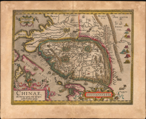
Chinae, olim Sinarum regionis, nova descriptio. auctore Ludovico Georgio.
$5,500.00
Acquire
- Digital Map Information
- Suitable for large format printing
- Full resolution TIFF file
- ICC color profile embedded
- Delivered instantly via download link
This is Abraham Ortelius' 1584 map of China, the first specific map of China, Southeast Asia, and the Philippines to appear in an atlas, here in an original-color example of a 1608 Vrients edition. This is the first printed European map of China and first atlas map to name the Philippines as an archipelago. This map remained definative regional map until superceded in 1655 maps of Martino Martini (卫匡国; 1614 - 1661). (more details)
Crete and the Greek Islands, as known to the Ancients.
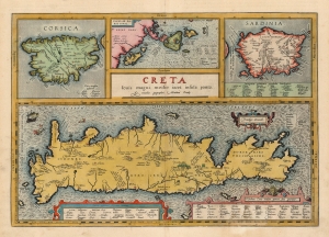
Creta Jovis magni medio iacet insula ponto.
$1,200.00
Acquire
- Digital Map Information
- Suitable for large format printing
- Full resolution TIFF file
- ICC color profile embedded
- Delivered instantly via download link
This is Abraham Ortelius' 1603 map of Crete and other Mediterranean islands as they were understood in antiquity and Greek mythology. The engraving is comprised of four separate maps of Corsica, Sardinia, the Ionian Islands, with Crete dominating all. The present example was published by Vrients, Ortelius' executor. The coloration of the atlases published by Vrients was unusually fine, so original color examples of Ortelius' maps of these editions are particularly desirable. (more details)
First Atlas Map specifically of Cyprus.
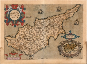
Cypri Insulae Nova Descript. 1573.
$900.00
Acquire
- Digital Map Information
- Suitable for large format printing
- Full resolution TIFF file
- ICC color profile embedded
- Delivered instantly via download link
This is a beautiful, original color example of Ortelius' 1573 map of Cyprus, combined with an inset map of Lemnos. Moreover, this is a Vrients edition of the map: maps from these editions typically exhibit finer quality color than those printed during Ortelius' lifetime and are consequently very desirable. (more details)