
Whitney, William Henry

William Henry Whitney (January 3, 1843 - May 4, 1909) was an American civil engineer active in Boston in the second half of the 19th century. Whitney was born in Needham, Massachusetts. He studied at Cambridge High School then at the Lawrence Scientific School of Harvard University. In July of 1862, he enlisted in the Union Army to fight in the American Civil War (1861 - 1865). He served honorably throughout the war, seeing action and suffering wounds twice. He left the service with the rank of Brevet-Major. He served as Alderman of Cambridge. and was involved with the Back Bay development project - producing multiple maps and plans. He began his studies as a civil engineer before the war in the office of Stephen P. Fuller. From 1869 - 1871 he worked in the Boston City Engineer's Office and was involved with the Back Bay development project - producing multiple maps and plans. In 1872, he entered into partnership with J. Franklin Fuller, son of S. P. Fuller. After a short time, Fuller retired and Whitney took full control of the firm, in 1888 renaming it William H. Whitney. As a private contractor he continued to work on the Back Bay. Also around this time, he completed multiple plans for the official records of the Civil War. Between 1889 and 1890, he took a contract with the Union Pacific to produce a series of maps of western cities, including Portland, Salt Lake City, Seattle, Astoria, Port Townsend, Spokane, and more. While he did not consider them an important part of his corpus, they are today arguably his most significant works, being among the earliest obtainable plans of those cities. He was also influential in introducing blueprint technology to American architecture and engineering.
Pueblo - the Pittsburg of the West?
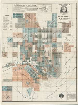
Map of Pueblo, Pueblo County, Colorado.
$4,000.00
Acquire
- Digital Map Information
- Suitable for large format printing
- File Size: 45.01 MB
- File Type: ZIP / TIFF
- ICC color profile embedded
- Delivered instantly via download link
A scarce 1888 map of Pueblo, Colorado, issued by W. H. Whitney. The map was issued at a heady time in Pueblo's development. Robust promotion, industrialization, and general regional prosperity led to rapid urbanization. The smaller towns of Pueblo (incorporated 1870), South Pueblo (incorporated 1873), and Central Pueblo (incorporated 1882) quickly grew into one another and legally consolidated as the City of Pueblo in 1886 - just two years before this map was issued. The present map is all about real-estate promotion, with developments named and color-coded, and individual blocks numbered where appropriate. (more details)
One of the earliest obtainable plans of Spokane, Washington.
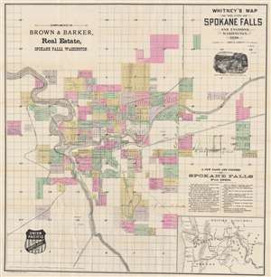
Whitney's Map of the City of Spokane Falls and Environs, Washington.
$1,400.00
Acquire
- Digital Map Information
- Suitable for large format printing
- Full resolution TIFF file
- ICC color profile embedded
- Delivered instantly via download link
This is the W. H. Whitney / John K. Ashley 1890 map of Spokane, Washington, one of the earliest obtainable maps of that city. Published when Spokane was known as Spokane Falls, the map is laid out as a cadastral map, allowing a detailed view of the city's early development. It further combines the functions of a real estate map and a railroad map. (more details)