This item has been sold, but you can get on the Waitlist to be notified if another example becomes available, or purchase a digital scan.
1720 Weigel Map of the Caucuses including Armenia, Georgia, and Azerbaijan
Armenia-weigel-1720$150.00

Title
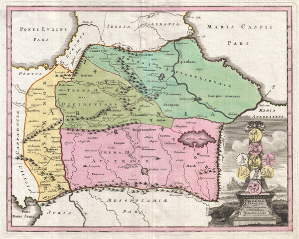
Armenia Vtraque.
1720 (undated) 13 x 16 in (33.02 x 40.64 cm)
1720 (undated) 13 x 16 in (33.02 x 40.64 cm)
Description
An uncommon 1720 map of the Caucuses by Christopher Weigel. This most unusual aspect of this map is its focus on the lands between the Black Sea and the Caspian, commonly known as the Caucuses. In antiquity most of this region was part of the Armenian Empire or Greater Armenia, a vast area of land stretching from Cappadocia and the Mediterranean to the Caspian and as far south as Persia. Later the Empire of Armenia was incorporated into the Roman Empire, the Byzantine Empire, and Persia. Today this region is divided between western Turkey, Georgia, Armenia and Azerbaijan. This map depicts Armenia at its greatest extant during the Roman Period. A title cartouche in the lower right quadrant includes 9 Roman coins on a decorative column. Published by Christopher Weigel for the 1720 issue of the Senca Historiarum Orientalis.
Cartographer
Christoph Weigel (November 9, 1654 - February 5, 1725) was a German goldsmith, printer, and engraver based in Nuremburg. Weigel apprenticed in engraving in the publishing center of Augsburg after which he held various positions in Vienna and Frankfurt. Eventually Weigel worked his way to 18th century printing Mecca of Nuremburg where, in 1698, he became a citizen of the city and established his own firm. Weigel is known to have worked closely with the most prominent of the Nuremburg map publishers J. B. Homann as well as with with his brother Johann Christoph Weigel (1654 - 1726) and the printer, Kohler. Following Weigel's passing in 1725, control of the firm passed to his widow, who published a number of Weigel's maps and atlases posthumously. The widow Weigel eventually ceded control of the firm to her son, Johann Christoph Weigel the younger (?? - 1746) who partnered with Schneider to publish as Schneider-Weigel. The Schneider-Weigel firm continued to publish until the early 19th century. More by this mapmaker...
Source
Weigel, C., Senca Historiarum Orientalis Quinti Seculi P.N. Chr., 1720.
Condition
Very good. Original centerfold. A couple margin reparis on verso.