
This item below is out of stock, but another example (left) is available. To view the available item, click "Details."
Details
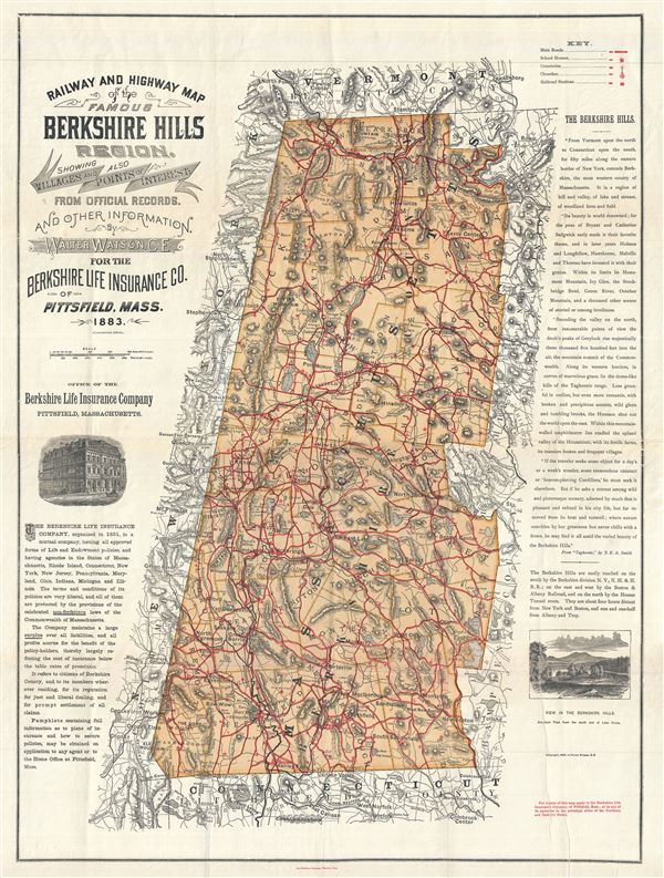
1896 Walter Watson Map of the Berkshires, Massachusetts
$500.00
1896 Walter Watson Map of the Berkshires, Massachusetts
Berkshires2-watson-1896$250.00

Title
Railway and Highway Map of the Famous Berkshire Hills Region, Showing Villages and also Points of Interest.
1896 (dated) 31 x 23 in (78.74 x 58.42 cm) 1 : 134376
1896 (dated) 31 x 23 in (78.74 x 58.42 cm) 1 : 134376
Description
This is a highly desirable 1896 map of the Berkshires or the Berkshire Hills in Massachusetts, by Walter Watson C. E. It covers Berkshire County, located in the western most part of the state of Massachusetts. Parts of the neighboring states of New York, Vermont and Connecticut and the counties of Hampden, Hampshire and Franklin are also included. This highly detailed map notes railways, ponds, lakes, railroads, roads, and a host of other topographical features. Hills and mountains are identified throughout, with individual heights noted, and elevation rendered by hachures. A key in the upper right quadrant notes the locations of main roads, school houses, cemeteries, churches and railroad stations marked in red on the map. The map notes the location of Shays' Fight, the armed uprising of 1787, near South Egremont.
Two beautiful illustrations are featured near the left and right borders of the map. The left illustration, of the office of the Berkshire Life Insurance Company in Pittsfield, Massachusetts is accompanied by a paragraph about the Life Insurance Company. The right illustration is a view of Greylock Peak (the highest point in Massachusetts) from the south end of Lake Onota. Above this illustration, along the right border, the Berkshire Hills are described in an excerpt from 'Taghconic,' by J. E. A. Smith. This map was first issued in 1883 and has been corrected to 1896. Map was created by Walter Watson, C. E., for the Berkshire Life Insurance Company of Pittsfield, Massachusetts.
Two beautiful illustrations are featured near the left and right borders of the map. The left illustration, of the office of the Berkshire Life Insurance Company in Pittsfield, Massachusetts is accompanied by a paragraph about the Life Insurance Company. The right illustration is a view of Greylock Peak (the highest point in Massachusetts) from the south end of Lake Onota. Above this illustration, along the right border, the Berkshire Hills are described in an excerpt from 'Taghconic,' by J. E. A. Smith. This map was first issued in 1883 and has been corrected to 1896. Map was created by Walter Watson, C. E., for the Berkshire Life Insurance Company of Pittsfield, Massachusetts.
Condition
Very good. Minor wear along original fold lines. Professionally flattened and backed with archival tissue. Minor printers crease lower right quadrant.