This item has been sold, but you can get on the Waitlist to be notified if another example becomes available, or purchase a digital scan.
1933 Surveyor General Map of Bombay (Mumbai), India
Bombay-surveyindia-1933$500.00

Title
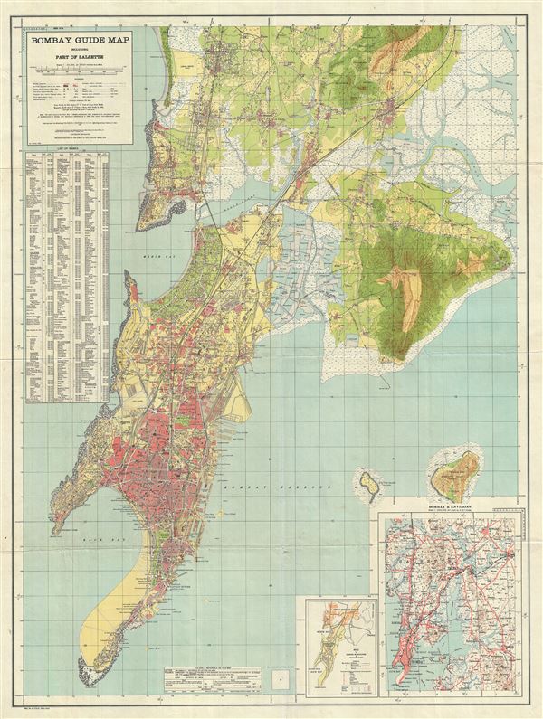
Bombay Guide Map including Part of Salsette.
1933 (dated) 41 x 30.5 in (104.14 x 77.47 cm) 1 : 25000
1933 (dated) 41 x 30.5 in (104.14 x 77.47 cm) 1 : 25000
Description
This is a scarce and attractive 1933 map of Bombay (Mumbai), India, issued by the offices of the Survey of India. It covers the island of Bombay in extraordinary detail from Colaba Point to Juhu and Vikhroli, and from Malabar point east as far as Trombay. It also includes Elephanta Island and Butcher Island. This highly detailed map notes streets, railways, parks, rivers, beaches, individual buildings, villages, and various other topographical features. Docks, churches, temples, social clubs, race courses etc. are also identified. A key referencing the map symbols is included below the title and a list of banks, colleges, consulates, courts, forts, railway stations, roads etc. is included along the left border. Two inset map featuring an index map to the districts, municipalities and municipal wards, and a map of the environs of Bombay, are included in the lower right quadrant of the map. This map was issued in 1933 and Bombay was witnessing the effects of the Great Depression of 1929. Its economy and mill industry would come to a standstill until 1939. This map was published under the direction of Colonel H.J. Couchman, D.S.O., M.C., Officiating Surveyor General of India in 1933.
Condition
Very good. Minor wear along original fold lines. Professionally flattened and backed with archival tissue.