This item has been sold, but you can get on the Waitlist to be notified if another example becomes available, or purchase a digital scan.
1780 Manuscript Illustration of the Battle of Camaret, France (1694)
CamaretFrance-manuscript-1780$3,250.00

Title
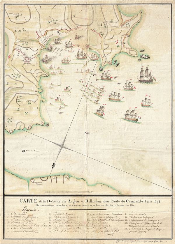
Carte de la Defcente des Anglais et Hollandais dans l'Anse de Camaret, le 18 Juin 1694.
1780 (dated) 26 x 18 in (66.04 x 45.72 cm)
1780 (dated) 26 x 18 in (66.04 x 45.72 cm)
Description
An extraordinary 1790 manuscript (hand drawn) illustration of the 1694 Battle of Camaret. Truly a masterwork of cartographic manuscript illustration, this map covers parts of Camaret Bay and Vaubon's fortifications at Camaret-sur-Mer, Brittany, France. The map or battle plan includes stunning representations of sailing ships (the Anglo-Dutch feet), French villages (Camaret-sur-Mer), farms, fortifications (the partially complete Tour Vaubon), and cannon batteries complete with smoking cannonballs. A legend at the base of the map identifies important sites using a numeric key. The whole is rendered in a fine and masterful hand with delicate, precise, period color. This illustration, by an unknown hand, claims to be copied from another manuscript illustration created after the battle in 1694. No trace of the original has been identified - making this the only surviving example.
The Battle of Camaret, part of the Nine Years War, was an amphibious attack by British and Dutch forces on Camaret-sur-Mer in an attempt to seize the nearby French port of Brest. The expansionist Sun King of France, Louis XIV, had withdrawn most of his navy to the Mediterranean in an attempt to support the Siege of Barcelona. The British and the Dutch, under the same King, William III, saw a unique opportunity to seize control of the strategic port of Brest, thus partially incapacitating French naval forces in the region. William III's forces, beautifully illustrated here, arrived at Camaret Bay with 36 ships of the line, 12 bomb vessels, 80 transport ships, and around 8,000 soldiers led by Thomas Tollemache. Facing them were some 1,300 Frenchmen under the engineer-military commander Sabastien Le Prestre, Seigneur de Vaubon. Vaubon had already toured the region in his efforts to make France's borders defensible. In Camaret-sur-Mer he ordered the construction of a defensive tower, now known as the Tour Vaubon, which was only partially complete in 1694. Nonetheless, Vaubon reinforced the tower and established batteries on nearby hills overlooking the bay - many of which are graphically represented here complete with miniature cannonballs wreaking havoc on the fleet. The resulting bombardment brought about the near total destruction of the numerically superior Anlgo-Dutch invasion fleet. The fleet's commander, Tollemache, later died from wounds suffered during the battle.
A rare opportunity to own a cartographic masterpiece in manuscript.
Condition
Very good. Minor verso repair along original fold lines. Else clean.