This item has been sold, but you can get on the Waitlist to be notified if another example becomes available, or purchase a digital scan.
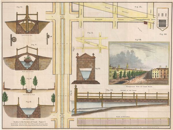
1860 Valentine Map of the Canal on Canal Street, New York
CanalStreetNewYorkCity-valentine-1860$100.00

Title
Perspective View of Canal Street. Scales to the Section of Canal.
1860 (dated) 17 x 22.5 in (43.18 x 57.15 cm)
1860 (dated) 17 x 22.5 in (43.18 x 57.15 cm)
Description
An unusual 1860 map illustrating the evolution of New York City's Canal Street. Canal Street, located in lower Manhattan, takes its name from a canal that was constructed in the early 19th century to drain the Collect Pond into the Hudson River. The Collect, as it is generally known, was a large pond located in lower Manhattan. In the 18th century it was a popular recreation area, however, by the early 19th century tanners, butchers, and others began using the Collect to dump their refuse, leading to problems with disease and pollution. In 1811 city attempted to drain the Collect and fill in the depression. Once the pond was filled the canal itself was also filled. This unfortunately led to more serious problems. Underground springs, lacking an outlet, undermined buildings all along the eastern portion of Canal Street, forcing affluent residents to flee the area, now once again plagued with disease. By the mid-19th century this area had degraded into the 'Five Points,' one of the world's most infamous slums and the subject of the Hollywood film, 'Gangs of New York.' This prospective of Canal Street was issued in 1860, at the height of the 'Five Points' mayhem and just one year before the events depicted in 'Gangs of New York.' Drawn by George Hayward, of 171 Pearl Street for publication in D. T. Valentine's Manual.
Cartographer
David T. (Thomas) Valentine (1801 - 1869) served as the Clerk of the Common Council of New York City. He edited and published a series of New York City almanacs and fact books entitled Manual of the Corporation of The City of New York. Valentine's Manual, as it came to be called, included facts about the City of New York, City Council information, city history, and reported on the progress of public works such as Central Park. The production of this annual manual was the responsibility of the Clerk of the City of New York, a position held at different times by D. Valentine and by Joseph Shannon (fl. c. 1850 - 1869), who also produced a similar manual. Valentine used his manual to reproduce some of the rarest and most important maps of New York City ever created. More by this mapmaker...
Source
Valentine, D. T., Valentine's Manual of the Corporation of the City of New York, (New York) 1860.
Condition
Very good. Original fold lines visible. Professionally flattened and backed with archival tissue.