This item has been sold, but you can get on the Waitlist to be notified if another example becomes available, or purchase a digital scan.
1924 Imperial Japanese Railway Map of Canton or Guangzhou, China
Canton-japgovtrail-1924$75.00

Title
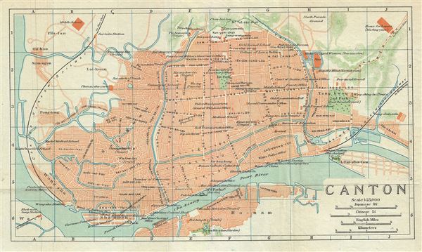
Canton.
1924 (undated) 6.5 x 11 in (16.51 x 27.94 cm) 1 : 25000
1924 (undated) 6.5 x 11 in (16.51 x 27.94 cm) 1 : 25000
Description
This is a 1924 map of Canton or Guangzhou or Kwangchow by the Imperial Japanese Government Railways. It covers part of Guangzhou, the largest city of the Guangdong province located on the Pearl River. This map is highly detailed and notes individual streets, buildings, rivers, parks, schools, government offices, as well as topography. The Canton-Hankow Railway line is also noted.
Today, Guangzhou and Guangdong Province account for the largest population in China and roughly 12% of China's industrial output. The map was issued as part of the 1924 Official Series Vol. D of the Guide to China and printed at the Toppan Printing Company.
Today, Guangzhou and Guangdong Province account for the largest population in China and roughly 12% of China's industrial output. The map was issued as part of the 1924 Official Series Vol. D of the Guide to China and printed at the Toppan Printing Company.
Source
Japanese Government Railways, Guide to China with land and sea routes between the American and European Continents, second (revised) edition, Tokyo, Japan, 1924.
Condition
Very good. Minor wear along fold lines.