This item has been sold, but you can get on the Waitlist to be notified if another example becomes available, or purchase a digital scan.
1944 Larmat Map of the Champagne Wine Region in France
Champagne-larmat-1944$300.00

Title
Les vins de Champagne
1944 (dated) 38 x 24 in (96.52 x 60.96 cm) 1 : 200000
1944 (dated) 38 x 24 in (96.52 x 60.96 cm) 1 : 200000
Description
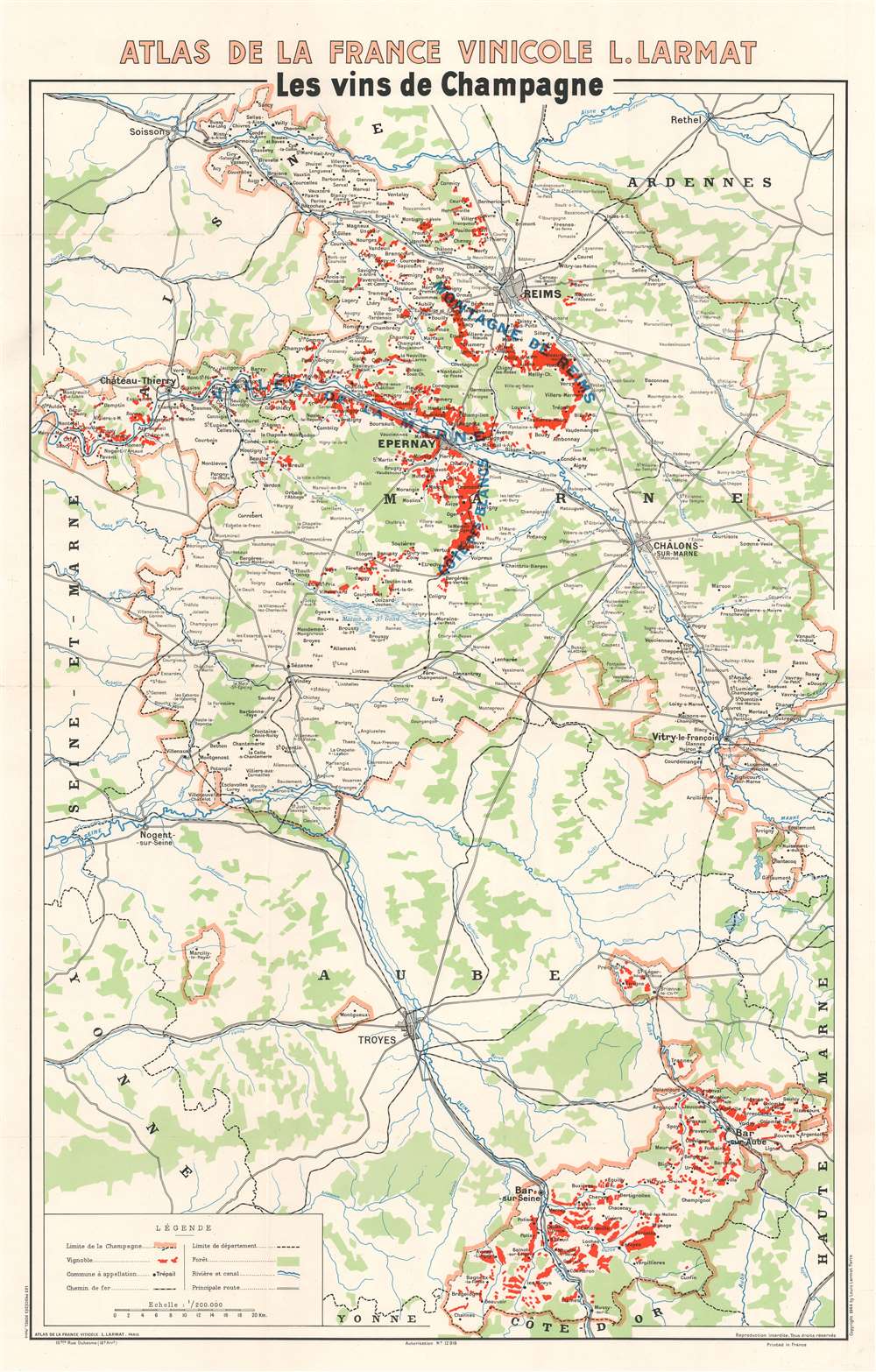
This is a 1944 Louis Larmat map of the Champagne wine region in France. Depicting from Soissons and Rethel to the Côte-d'Or and from Ste. Aulde in the Champagne region to the Departement de la Haute-Marne, thick pink lines surround the Champagne wine region, which is not a geographically contiguous area. Within the Champagne region, small towns and hamlets associated with the Champagne industry are labeled, and areas shaded red highlight vine-growers. Major cities in and around the Champagne region include Reims, Châlons-sur-Marne, and Troyes. Major roads and railroads are illustrated, along with rivers, swamps, and forested areas. In many parts of the world, in order for a wine to be labeled as Champagne unless it came from the Champagne wine region of France.
Publication History and Census
This map was created by Lous Larmat and published in 1944 in Volume IV of his Atlas de la France Vinicole dedicated to 'Les vins de Champagne.' Six examples are cataloged in OCLC and are part of the institutional collections at Cornell University, the University of Toronto, the University of Laval in Québec, the University of California Davis, the Zurich Library, and the University of Hawaii at Manoa.Cartographer
Louis Larmat (19xx - xxxx) was a French publisher and cartographer active during the mid-20th century. Larmat published the world's first national wine atlas, his Atlas de la France Vinicole between 1941 and 1947. Divided into six volumes, each volume focused on a specific wine producing region. Volume one detailed wines from Bordeaux and subsequent volumes focused on Bourgogne, les côtes du Rhône, Champagne, les coteaux de la Loire, and the eaux-de-vie de France and cognac. Subsequent editions were published in 1949 and 1953, many of which were updated. It also appears that Larmat intended to produce a series of road maps meant for self-guided wine tours, the 'route des grand crus.' Only one of these is known to exist and focuses on the Bordeaux region. This map was not simply taken from the atlas focusing on Bordeaux. It was a new creation and includes the main roads and vignettes of several of the chateaux. Very little is known about Larmat's life and career apart from the Atlas de la France Vinicole. The Bibliothèque nationale de France notes that he was a publisher in Paris (éditeur Parisien) and provides two Parisian addresses. His earliest accredited publication dates to 1924 and was published in Nice, which suggests the Larmat may have begun his career there. He also published three separate maps later in his career: the general 'Carte de la France Vinicole' by Marcel Azema in 1945, the 'Carte du Vignoble Alsacien' by Robert Louis in 1949, and 'L'Algérie Vinicole' by Georges Lafosse in 1954. More by this mapmaker...
Source
Larmat, L. Atlas de la France Vinicole. Tome IV. Les Vins de Champagne (Paris: Larmat) 1944.
Condition
Very good. Old repaired tear extending two inches into printed area in top right corner professionally repaired on verso. Verso repairs at two fold intersections. Blank on verso.
References
OCLC 888863470.