This copy is copyright protected.
Copyright © 2024 Geographicus Rare Antique Maps

Details
1584/1602 Ortelius Map of China and the Philippines: Original Vrients Color
1584 (dated) $6,500.00
1608 Ortelius Map of China and the Philippines
China-ortelius-1608
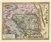

This round lake in the province of Sancii was made by a flood in the year 1557, during which seven cities were submerged, as well as towns and villages, and a very great number of dead people were the result, except for one boy only, who was saved by means of a tree trunk.The story appears to refer to the great 1556 Shaanxi Earthquake - in the aftermath of which a great deal of flooding and landslides occurred. The 1556 quake has been estimated to have been a magnitude 8 earthquake; immediately as many as 830,000 Chinese living in loess caves (yaodongs) on high cliffs were killed as the earthquake initiated a horrific cascade of landslides and floods. Chinese annals describe it:
Mountains and rivers changed places and roads were destroyed. In some places, the ground suddenly rose up and formed new hills, or it sank abruptly and became new valleys. In other areas, a stream burst out in an instant, or the ground broke and new gullies appeared. Huts, official houses, temples and city walls collapsed all of a sudden.Further flooding occurred for months following the initial earthquake.
Abraham Ortelius (April 14, 1527 - June 28, 1598) also known as Ortels, was a cartographer, geographer, and cosmographer of Brabant, active in Antwerp. He was the creator of the first modern atlas, Theatrum Orbis Terrarum and is a seminal figure in the history of cartography. Along with Gerard Mercator and Gemma Frisius, he was a founder of the Netherlandish school of cartography. His connections with Spain - culminating in his 1575 appointment as Royal Cartographer to King Phillip II of Spain - gave him unmatched access to Spanish geographical knowledge during a crucial period of the Age of Discovery. Ortelius was born in 1527 in Antwerp. In 1547 he entered the Antwerp Guild of Saint Luke as an illuminator of maps. He began trading in books, prints, and maps, traveling regularly to the Frankfurt book and print fair, where in 1554 he met Mercator. He accompanied Mercator on journeys throughout France in 1560 and it was at this time, under Mercator's influence, that he appears to have chosen his career as a scientific geographer. His first published geographic work appeared in 1564, an eight-sheet cordiform world map. A handful of other maps preceded the 1570 publication of the first edition of the Theatrum Orbis Terrarum, which would prove to be his life work. Appearing with but 53 maps in its first edition, Ortelius' work expanded with new maps added regularly. By 1592, it had 134 maps. Many of Ortelius' maps remained the standard for nearly a century. He traveled extensively, but his genius was as a compiler, locating the best informed maps on which to base his own. His contacts throughout Europe and extending even (via the Portuguese) to the Far East were formidable. Moreover, many of his maps were based on his own scholarship, particularly his historical works. His theories of geography were particularly ahead of his time with respect to the notion of continental drift, the possibility of which he mused on as early as 1596, and which would be proven correct centuries later.
In a sense his greatest achievement was his successful navigation of the religious and political violence endemic to his city throughout his adult life: The Dutch Revolt, or Eighty Years' War (1568 - 1648), fully embroiled Antwerp. Although outwardly and officially recognized as Catholic (Arias Montanus vouched for Ortelius' Catholic orthodoxy prior to his appointment as Royal Geographer), Ortelius was able to separate himself from the religious furor which characterized the war in the low countries. Ortelius showed a glimpse of himself in a letter to a friend, regarding humanist Justus Lipsius: 'I do not know whether he is an adherent of the Pope or a Calvinist, but if he has ears to hear, he will neither be one nor the other, for sins are committed on both sides'. Ortelius' own explorations of Biblical history in his maps, and the Christogram contained in his own motto, suggest him to be a religious man, but his abjuration of political religious authorities mark him as an individualist. His tombstone at St Michael's Præmonstratensian Abbey in Antwerp bears the inscription, Quietis cultor sine lite, uxore, prole. ('served quietly, without accusation, wife, and offspring.') More by this mapmaker...
Luiz Jorge de Barbuda (1564? - 1613? ) was a Portuguese cartographer. He is known primarily as the individual credited by Abraham Ortelius as the source for During his 1584 map of China, the first map specifically of China to appear in an atlas. Little is known of his early history and there is little agreement by scholars on his dates. It is understood that he was, in 1582, commissioned by Philip II of Spain to produce navigation charts and world maps. His role as an official cartographer for Spain makes the appearance of his map in Ortelius' atlas all the more remarkable: The Spanish were reluctant to share any of their cartographic information and printed virtually none of it in the 16th and 17th centuries. Nevertheless, his Chinaeappeared in Ortelius' Theatrum Orbis Terrarum accompanied by a brief description of China and its language, derived from Bernardino de Escalante's 1577 Discurso de la navegacion que los Portugueses hacen a los Reinos y Provincias de Oriente, Spain's first book about China. Both the map and the description published in Ortelius' work would remain the most authoritative European description of China until Martini's 1655 work became available. Learn More...
Johannes Baptista Vrients (1552-1612) was a Flemish engraver, publisher and mapseller. Little is known of his early years, but it is to be assumed he came up as an apprentice among the mapmakers of Antwerp, where the guild named him a master in 1575. In the 1590s he executed world maps for Plancius and Linschoten. (In 1600 he became executor for Ortelius, and acquired the plates for the Theatrum after that mapmaker's death. He would go on to publish further editions of the Ortelius atlas between 1606 and 1612. Vrients also acquired the plates for De Jode's Speculum in and around 1600, but he did not republish that work - though he would preserve the De Jode plates depicting the Electors of the Holy Roman Empire, reprinting it in his editions of the Ortelius atlas after 1603. Vrients' editions of the Theatrum were not published in Antwerp (that city having fallen during the Dutch war with Spain) but in Amsterdam. Learn More...
Copyright © 2024 Geographicus Rare Antique Maps | Geographicus Rare Antique Maps
This copy is copyright protected.
Copyright © 2024 Geographicus Rare Antique Maps