This item has been sold, but you can get on the Waitlist to be notified if another example becomes available, or purchase a digital scan.
1838 Slacum Map of the Coumbia River, Washington
ColumbiaRiver-slacum-1838$225.00

Title
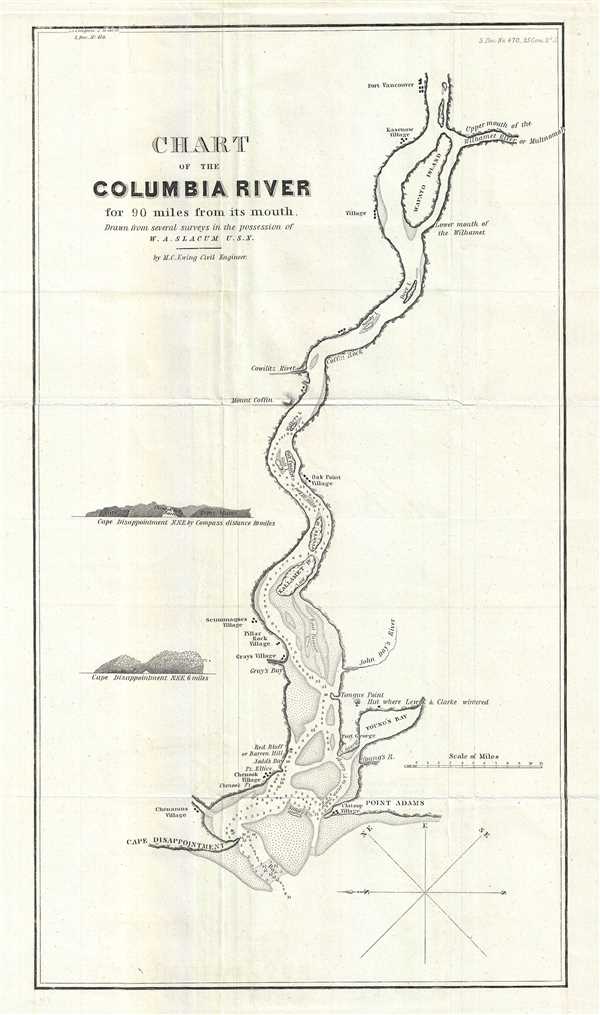
Chart of the Columbia River for 90 miles from its mouth.
1838 (undated) 17 x 9.5 in (43.18 x 24.13 cm) 1 : 350000
1838 (undated) 17 x 9.5 in (43.18 x 24.13 cm) 1 : 350000
Description
This is an important and scarce 1838 map or nautical chart of the Columbia River by William A. Slacum. The Columbia River, the largest river in the Pacific Northwest region of the United States forms the border between the states of Washington and Oregon. This map covers from Cape Disappointment to Fort Vancouver. Prepared to illustrate the report of Senator Linn on a Bill to ‘authorize the President to occupy the Oregon Territory,' the map offers exceptional detail throughout and includes depth soundings, sand bars and islands. The map marks Fort George (also called Fort Astoria) and Fort Vancouver along with several Indian villages. It also notes the location of the ‘Hut where Lewis and Clark wintered’ near Young’s Bay and Fort George. Two coastal profiles of Cape Disappointment are also included.
In 1818, United States and Britain agreed to joint occupancy of the Oregon County. Both the British, in the name of the Hudson Bay Company, and the Americans, championed by John Jacob Astor's Pacific Fur Company, were eager to claim monopolistic right over the region. Astor's establishment of Fort Astoria or Ft. George on the Columbia River, identified here, only served to further tensions with the Northwest Company - the Pacific subsidiary of the Hudson Bay Company. The dispute would escalate, giving rise to the Oregon Boundary Dispute and the American expansionist slogan 'Fifty-four Forty or Fight!.'
In 1835, President Andrew Jackson assigned William A. Slacum to travel to the Oregon Territory to gather information. He returned to the United States in 1837 and prepared a report advocating the extension of the jurisdiction of the United States with a border of no further south than the 49th parallel.
In 1838, Senator Lewis F. Linn presented his report to the Select Committee on the Oregon Territory of the United States Senate. This map was a part of that report. Of this particular map, the committee said, ‘The map of the Territory of Oregon, and chart of the Columbia River, which accompany this report, are believed to be the most correct, and furnish the most recent and authentic information, of any yet published, and were prepared by Colonel Abert, of the Topographical Bureau, with much care and labor. The chart was made by Mr. Slacum, after his recent visit to Oregon.’ The dispute was not resolved until the 1846 Oregon Treaty which, through concessions on both sides, formally set the boundary at the 49th parallel.
This map was prepared by M. C. Ewing, civil engineer, from several surveys in the possession of W. A. Slacum U.S.N. and was part of the historically important Report of Mr. Linn, Senate Document No. 470, 25th Congress, 2nd Session, dated June 6, 1838, to Accompany Senate Bill No. 206, to authorize the President to occupy the Oregon Territory presented to the United States Congress Senate Select Committee on the Oregon Territory. A map of historic significance, making it one of the most desirable maps of the region.
Source
Report of Mr. Linn, Senate Document No. 470, 25th Congress, 2nd Session, dated June 6, 1838, to Accompany Senate Bill No. 206, to authorize the President to occupy the Oregon Territory.
Condition
Very good. Minor wear along original fold lines. Minor spotting.
References
OCLC: 166636985.