This item has been sold, but you can get on the Waitlist to be notified if another example becomes available, or purchase a digital scan.
1834 S.D.U.K. Comparative Map or Chart of the World's Great Rivers
ComparativeRivers-sduk-1834$75.00

Title
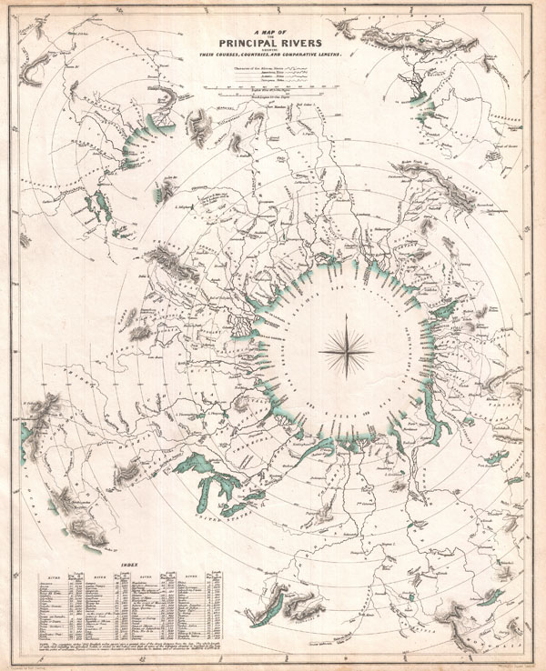
A Map of the Principal Rivers shewing their Courses, Countries, and Comparative Lengths.
1834 (dated) 16 x 13 in (40.64 x 33.02 cm)
1834 (dated) 16 x 13 in (40.64 x 33.02 cm)
Description
This curious comparative rivers chart published in 1834 by the Society for the Diffusion of Useful Knowledge is somewhat unique in that it imagines all of the great rivers of the world letting out into a circular inland sea. Concentric circles show the general lengths of the rivers as the bird files, but cannot take into account the twists and turns of the rivers themselves. What this chart does show is, to a degree, the direction and course of the rivers' flow. Direction, which in other comparative rivers charts is indicated textually, here is illustrated visually. Nevertheless, though innovative and physically attractive, this S.D.U.K. comparative rivers chart never caught on beyond its initial publication. Drawn by Baldwin and Craddock of 47 Paternoster Row, London, for the Society for the Diffusion of Useful Knowledge Atlas, volume 1. Dated and copyrighted April 1, 1834.
Cartographer
The "Society for the Diffusion of Useful Knowledge" (1826 - 1848) was a Whiggish organization founded in 1828 at the instigation of idealistic British lord Henry Peter Brougham. The admirable goal of the Society was to distribute useful information via a series of publications to the English working and middle classes. It promoted self-education and the egalitarian sharing of all knowledge. While closely tied to the London University and publishing houses on the order of Baldwin and Cradock, Chapman and Hall, and Charles Knight, the Society failed to achieve its many lofty goals in finally closed its doors in 1848. Most likely the failure of the Society resulted from its publications being too expensive for its intended lower to middle class markets and yet not large and fine enough to appeal to the aristocratic market. Nonetheless, it did manage to publish several extraordinary atlases of impressive detail and sophistication. Their most prominent atlas consisted of some 200 separately issued maps initially published by Baldwin and Cradock and sold by subscription from 1829 to 1844. Afterwards, the Society combined the maps into a single world atlas published under the Chapman and Hall imprint. In its day, this atlas was unprecedented in its quality, scope, and cost effectiveness. Today Society, or S.D.U.K. as it is commonly known, maps are among the most impressive examples of mid-19th century English mass market cartographic publishing available. The S.D.U.K. is especially known for its beautiful and accurately detailed city plans. More by this mapmaker...
Source
Maps of the Society for the Diffusion of Useful Knowledge. Vol. 1. London: Chapman and Hall, 186, Strand, 1844.
Condition
Very good. Minor marginal toning.
References
Rumsey 0890.159.