This item has been sold, but you can get on the Waitlist to be notified if another example becomes available, or purchase a digital scan.
1765 Benjamin Donn Wall Map of Devonshire and Exeter, England
Devon-donn-1765$2,000.00

Title
A Map of the County of Devon, with the City & County of Exeter.
1865 (dated) 73 x 76 in (185.42 x 193.04 cm)
1865 (dated) 73 x 76 in (185.42 x 193.04 cm)
Description
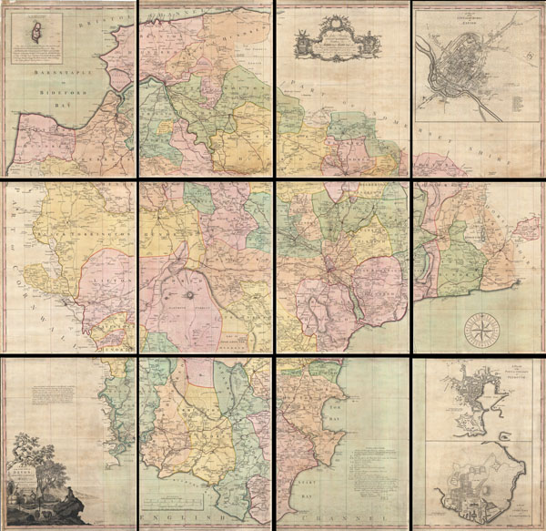
This is a very rare and highly important 1765 wall map of Devonshire by Benjamin Donn. Drawn in twelve panels, this map covers the entirety of Devonshire or Devon from the English Channel to Barnstaple (Bideford) Bay and from Cornwall to Somerset at a scale of 1 inch to 1 mile. Donn also incorporates large insets of Exeter (showing the college), Plymouth, Plymouth Dock, Stoke Town, and the Isle of Lundy. An elaborate decorative title cartouche with various allegorical elements appears in the lower left quadrant.
In 1759 the Society for the Encouragement of the Arts, Manufacturers, and Commerce (since 1847 known as the Royal Society for the Arts), following the suggestion of the Cornish antiquarian William Borlase, offered a £100 award for a large scale one inch to the mile map of any English county. Benjamin Donn, the first to step up to the Borlase's challenge, began work on his map of Devon in 1760. Five years later Donn's extraordinary project reached completion. The Society was awed by the magnitude and detail of Donn's 'accurate, actual survey' and promptly awarded him the £100. Though the actual work of completing the survey and print the map cost Donn, by his own estimation, nearly £2000, the prestige of issuing the first large scale British county map earned him both robust subsequent sales and the admiration of his peers.
Donn's vast map of Devon and Exeter offers a wealth of detail and stands up to extensive study. As the first significant large scale British county map, this remarkable chart introduces a number of cartographic conventions that would become standardized in subsequent county and regional maps. These include Donn's techniques for rendering turnpike roads versus fenced roads versus open roads as well as his innovative iconography relating the identification of farms, cottages, churches, villages, and estates. In addition to the inclusion of typical cartographic features, it also includes such oddities as country inns, pleasure houses, lime kilns, the birthplace of Sr. Walter Raleigh, potato markets, ancient roman ruins, druidic ruins, subterranean passages, mileage, elevation and some 656 gentleman's seats.
This map was drawn and surveyed by Benjamin Donn and printed by Thomas Jeffreys in twelve separate but joinable panels. Donn dedicated his map to John Baring of Mount-Radford and Matthew Lee of Ebford, local notables who may have helped Donn finance his survey work. This is a highly decorative and unusual example of this particular map. Most examples of this map appear bound in book format with large centerfolds and outline or no color. This unusual example must have been prepared at a special request and is the only full original color example we have seen. It is recorded that Donn charged 2 extra shillings for binding and 5 extra for coloring, and an additional unknown premium for exceptionally fine full coloring. Further, this example has clearly never been bound or folded and each panel is neatly backed with linen. It is our belief that this is special order variant of the first edition and as such is a unique find. Presents dramatically spaced in a single large frame or in a sequence of narrowly set individual frames.
CartographerS
Benjamin Donn (1729 - 1798), sometimes known as Benjamin Donne, was a British cartographer, surveyor, and mathematician active in England during the middle to late 18th century. Born in Bidford, England, Benjamin Donn was the heir to long line of well-respected mathematicians, including his father and older brother, who ran a local school. Early on he developed an interest in surveying and astronomy and from 1749 to 1756 was a regular contributor to the "Gentleman's Diary" where he published accounts of his astronomical observations. In 1768 he was elected librarian of the Bristol Library, and, "in keeping with his taste for the binomial theorem and the book of Euclid, he conceived the idea of converting the establishment into a mathematical academy; but the corporation did not join in his enthusiasm, and students were not invited." Later he established his own private mathematical academy in Bristol near St. Michael's Church. Cartographically, Donn's most significant work is his 1765 large format map of Devonshire, based upon a mile for mile survey he completed at his own expense. This was the first large scale map of any British county and won Donn lasting fame as well as a £100 gratuity from the Royal Society for the Arts. Donn later went on to publish a number of other less significant but popular maps including a pocket map of Bristol, a map of western England, and several nautical charts of the Western Ocean, as well as various mathematical tables. A lifetime of study and dedication to mathematics earned Donne the title of Master of Mechanics to the King, an honorarium he would hold for only a short time. Donn died in 1798. More by this mapmaker...
Thomas Jefferys (1695 - November 20, 1771) was one of the most prominent and prolific map publishers and engravers of his day. Jefferys was born in Birmingham and was apprenticed to the engraver Emmanuel Bowen in 1735. Later, in the 1740s he engraved several maps for the popular periodical Gentleman's Magazine. Around 1740 Jefferys was finally able to go into business for himself and in 1746 received an appointment as 'Geographer to Fredrick, Prince of Wales,' which shortly after translated to the position of 'Royal Cartographer to King George III.' Jefferys initially specialized in compiling and re-engraving the works of earlier cartographers into more coherent cartographic wholes. Later, while not salaried position, Jefferys' appointment as 'Royal Cartographer' guaranteed preferential access to the most up to date cartographic material available, allowing him to produce new and updated charts of exceptional accuracy. He his best known for his maps of the Americas, particularly the posthumously published 1775 American Atlas, which included some of the finest and most important late colonial era maps of America ever made. Despite his prolific publishing history, royal appointments, and international publishing fame, Jefferys lived most of his life in dire economic straits. He was bailed out of bankruptcy by Robert Sayer during the production of the American Atlas. In the end, Jefferys died suddenly with very little to his name. Nonetheless, his cartographic legacy survived, and even after his death in 1771, many of his important maps continued to be published and republished by Sayer and Bennet, Conrad Lotter, Georges Louis Le Rouge, Laurie and Whittle, and others. Many attribute some of Jefferys best maps to the colorful and criminally inclined Irish cartographic genius Braddock Mead (John Green, c. 1688 - 1757), who is considered the 'secret behind Jefferys.' Jefferys was succeeded by his son, also Thomas, who had little success as a cartographer and eventually partnered with, then sold his stock and plates to William Faden - Jefferys' true heir. Learn More...
Condition
Very good condition. Issued in 12 separate linen backed panels. Minor edge wear. Else very clean. Given size represents the size of the map if fully assembled. Individual panels measure 24 x 19 inches.
References
Rodger, E.,The Large Scale County Maps of the British Isles: 1596-1850, 82. Batten, K. and Bennett, F., Printed Maps of Devon. National Library of Australia, Petherick Reading Room, Rbef CLI 4459.