This item has been sold, but you can get on the Waitlist to be notified if another example becomes available, or purchase a digital scan.
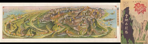
1939 Showa 14 Panorama Map of Diamond Mountain, Kumgangsan, Korea
DiamondMountain-showa14-1939$125.00

Title
Kumgangsan.
1939 (dated) 7 x 21 in (17.78 x 53.34 cm)
1939 (dated) 7 x 21 in (17.78 x 53.34 cm)
Description
An extremely attractive 1939 or Showa 14 panoramic view map of Kumgangsan or Diamond Mountain, North Korea. Also known as Mount Kumgang, Diamond Mountain is an important tourist destination in North Korea. Diamond Mountain is one of the few areas in North Korea that is open to foreign tourism and regularly visited by international travelers. Kumgangsan has been known for its scenic beauty since antiquity and is the subject of many different works of art. Including its spring name, Kumgang (Hangeul, Hanja), it has many different names for each season, but it is most widely known today as Kumgangsan. In summer it is called Pongraesan (the place where a Spirit dwells); in autumn, Phung'aksan (hill of colored leaves, or great mountain of colored leaves); in winter, Kaegolsan (stone bone mountain). The various mountains are shown in profile, as is the issuer's 'Diamond Mountain electric Railway.' This uncommon type of map evolved out of traditional Japanese view-style cartography and began to appear in Japan, Taiwan, and Korea in the early 20th century. Generally speaking such maps coincided with the development of railroad lines throughout the once vast Dai Nippon Teikoku or Japanese empire. It is a distinctive style full of artistic flourish that at the same time performs a practical function. This particular example is both relatively early and exceptionally beautiful. It was printed via a multi-color lithographic process with delicately shaded tones and an easily comprehensible intuitive design. Shows villages, famous sights, roadways, and rail lines. Folds into itself, accordion style, with a photographic cover depicting Diamond Mountain. Verso features additional Japanese text and a smaller transportation map.
Condition
Very good. Original folds. Some edge wear. Else clean.