1851 Black Map of England and Wales
EnglandWales-black-1851$150.00

Title
England and Wales.
1851 (undated) 33 x 24 in (83.82 x 60.96 cm)
1851 (undated) 33 x 24 in (83.82 x 60.96 cm)
Description
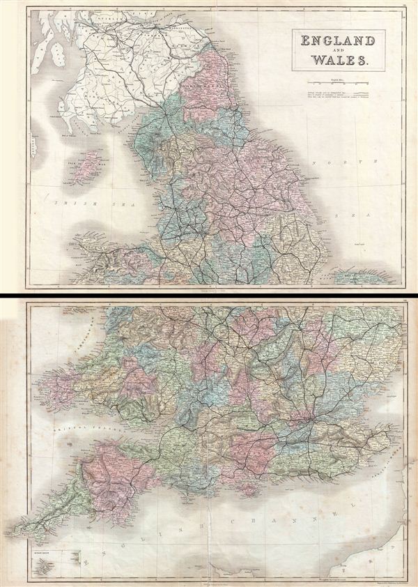
A fine example of Adam and Charles Black's 1851 map of england and Wales. The map, on two sheets, covers both england and Wales from Northumberland to Cornwall, including the Isle of Man and adjacent parts of Scotland. Small inset map on lower right quadrant of the map (on second sheet) details the Scilly Isles. As this map was issued, both england and Wales were in the midst of the Industrial Revolution wherein much of the rural agricultural population relocated to urban centers. Throughout, the map identifies various cities, towns, rivers, lakes, roadways and an assortment of additional topographical details. Map is hand colored in pink, green, blue and yellow pastels to define regional and political boundaries. The map is engraved by S. Hall and issued as plate nos. VII and VIII in Black's General Atlas.
Cartographer
Charles and Adam Black (fl. 1807 - present) were map and book publishers based in Edinburgh. Charles and his uncle, Adam, both of Edinburgh, Scotland, founded their publishing firm in 1807. They published a series of maps and atlases throughout the 19th century. In addition to an array of atlases, the Black firm is known for their editions of the Encyclopedia Britannica (1817 - 1826) and the first publishing of Sir Walter Scott's novels in 1854. In 1889 the A. & C. Black publishing house moved to London where it remains in operation to this day. More by this mapmaker...
Source
Black, A. and C., General Atlas Of The World, (Edinburgh) 1851.
Condition
Very good. Overall toning and light foxing. Verso repair along centerfold. Original platemark visible.
References
Rumsey 2305.013, 2305.014, 2305.015 (1854 edition). Philips (atlases) 4334.