This item has been sold, but you can get on the Waitlist to be notified if another example becomes available, or purchase a digital scan.
1854 Public Survey Land Office Map of Central Florida near Tampa
FloridaTampa-publicsurvey-1854$125.00

Title
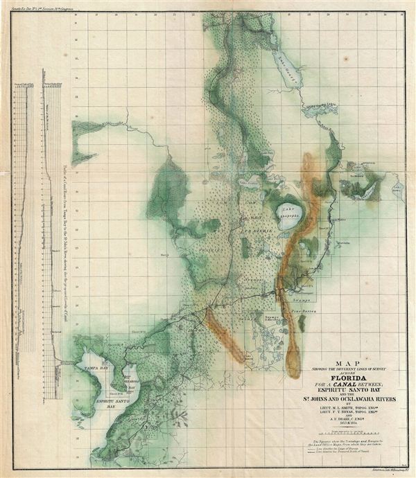
Map Showing the Different Lines of Survey Across Florida for a Canal Between; Espiritu Santo bay and the St. Johns and Ocklawaha Rivers.
1854 (dated) 16.5 x 14 in (41.91 x 35.56 cm)
1854 (dated) 16.5 x 14 in (41.91 x 35.56 cm)
Description
This is an attractive example of the 1854 public survey map of Florida for the proposed canal across the espiritu Santo Bay and the St. Johns and Ocklawaha Rivers. This beautiful hand colored map covers Florida from Lake George in the north to Maniti River in the south and from Tampa Bay east as far as Lake Hamey.
With the increase in population and the growing rise of Florida's agricultural industry, mostly through the introduction of slave labor, a canal was proposed to aid transportation of goods to and from central Florida. This map marks the proposed route of the canal along with survey lines and townships. Profiles showing the proposed levels of the canal route from Tampa Bay to the St. John's River are featured along the left margin of the map. Although surveyed and discussed thoroughout the 1840s and 1850s, various delays prevented it from being constructed. With the advent of the Great Age of Trains, a railroad was eventually constructed along the same route.
The cartographer notes various forts, swamps, creeks, rivers, lakes, prairies, and various other topographical features in the area. Relief is shown in hachures. This map is printed by Ackerman and prepared by topographical engineers M. L. Smith and F. T. Bryan along with Army Corps of engineers specialist A. e. Drake.
Cartographer
The General Land Office (1812 - 1946) was an independent agency charged with the administration and sale of public lands of the western territories of the United States under the Preemption Act of 1841 and the Homestead Act of 1862. During a time of frenetic energy and rapid westward expansion, the Land Office oversaw the surveying, platting, mapping and eventually the sale of much of the Western United States and Florida. The structural layout of the western United States that we see today, and many of their district and county divisions, are direct result of the early surveying work of the General Land Office. More importantly, as a branch of the Federal Government in Washington D.C. and the only agency able to legally sell and administer public lands in the western territories of the United States, the General Land Office played a pivotal role in consolidating power away from the original states and into the hands of the centralized federal government. The General Land Office was absorbed into the Department of Interior in 1849 and in 1946 merged with the United States Grazing Service to become the Bureau of Land Management. Today the Bureau of Land Management administers the roughly 246 million acres of public land remaining under federal ownership. More by this mapmaker...
Source
Maps and Views to Accompany Message and Documents 1855-56, (Washington: Nicholson) 1856.
Condition
Very good. Original fold lines visible. Minor discoloration over fold lines. Blank on verso. Professionally flattened and backed with archival Japanese tissue.
References
Servies, J. A., A Bibliography of West Florida, #3950, 4138.