This item has been sold, but you can get on the Waitlist to be notified if another example becomes available, or purchase a digital scan.
1747 Bowen Map of Germany, Austria, Switzerland, Bohemia and the United Provinces
Germany-bowen-1747$100.00

Title
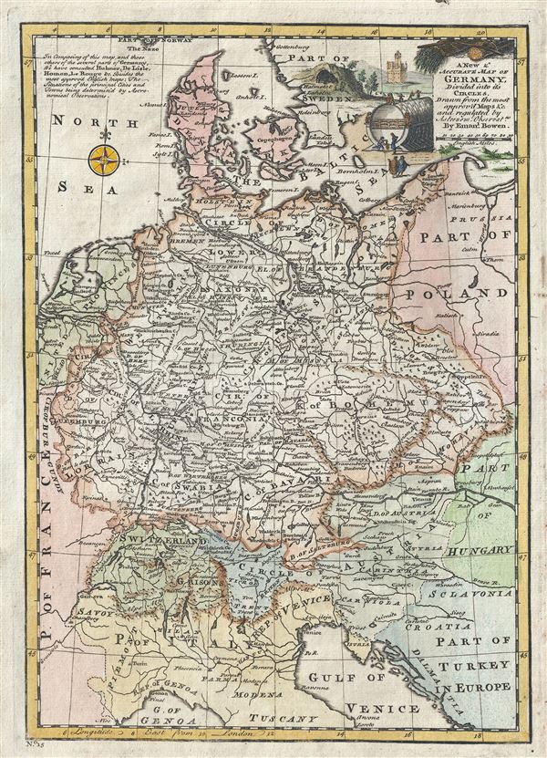
A New and Accurate Map of Germany Divided into its Circles.
1747 (undated) 13 x 9.5 in (33.02 x 24.13 cm) 1 : 5100000
1747 (undated) 13 x 9.5 in (33.02 x 24.13 cm) 1 : 5100000
Description
This is a beautiful 1747 map of Germany by the British cartographer Emanuel Bowen. It covers Germany during the mid-18th century, which included all of modern day Germany, Austria, Switzerland, Czech Republic, the Netherlands, Denmark and parts of Eastern Europe. Parts of northern Italy, Poland and Hungary are also included.
The map divides the area into the 'imperial circles,' devised by the Holy Roman Empire. The 'imperial circles,' covering most of what is now Central Europe, were administrative units created for tax and defense purposes by the Holy Roman Empire in the 1500s. The Napoleonic Wars would, of course, dissolve the Holy Roman Empire and lead to the consolidation of Germany in 1871.
Throughout, several towns, cities, rivers, lakes, roads and a host of additional topographical features are noted, with mountains beautifully rendered in profile. A beautiful title cartouche is included in the top right quadrant. Bowen notes that this map was based on earlier maps by Hubner, Delisile, Homann and Le Rouge. Prepared by Emanuel Bowen as plate no. 15 for the 1747 issue of A Complete System of Geography.
Cartographer
Emanuel Bowen (1694 - May 8, 1767) had the high distinction to be named Royal Mapmaker to both to King George II of England and Louis XV of France. Bowen was born in Talley, Carmarthen, Wales, to a distinguished but not noble family. He apprenticed to Charles Price, Merchant Taylor, from 1709. He was admitted to the Merchant Taylors Livery Company on October 3, 1716, but had been active in London from about 1714. A early as 1726 he was noted as one of the leading London engravers. Bowen is highly regarded for producing some of the largest, most detailed, most accurate and most attractive maps of his era. He is known to have worked with most British cartographic figures of the period including Herman Moll and John Owen. Among his multiple apprentices, the most notable were Thomas Kitchin, Thomas Jeffreys, and John Lodge. Another apprentice, John Oakman (1748 - 1793) who had an affair with and eventually married, Bowen's daughter. Other Bowen apprentices include Thomas Buss, John Pryer, Samuel Lyne, his son Thomas Bowen, and William Fowler. Despite achieving peer respect, renown, and royal patronage, Bowen, like many cartographers, died in poverty. Upon Emanuel Bowen's death, his cartographic work was taken over by his son, Thomas Bowen (1733 - 1790) who also died in poverty. More by this mapmaker...
Source
Bowen, E., A Complete System of Geography. Being a description of all the countries, islands, cities, chief towns, harbours, lakes, and rivers, mountains, mines, etc., of the known world …, (London) 1747.
Condition
Very good. Original platemark visible. Blank on verso.
References
Rumsey 3733.014. Philips (atlases) 614 (1752 edition).