This item has been sold, but you can get on the Waitlist to be notified if another example becomes available, or purchase a digital scan.

1904 Clason Map or View of the Gilpin Colorado Gold and Mineral Belt

GilpinCountyColorado-clason-1904
$200.00
Topographical Map Gilpin County Colo. Mineral Belt Gold Production $125,000,000.00. - Main View
Processing...

1904 Clason Map or View of the Gilpin Colorado Gold and Mineral Belt

GilpinCountyColorado-clason-1904

Important view illustrating the Colorado Gold Rush.

Title


Topographical Map Gilpin County Colo. Mineral Belt Gold Production $125,000,000.00.
  1904 (undated)     25 x 18.75 in (63.5 x 47.625 cm)

Description


This is a stunning 1904 broadside bird's eye view or map of Gilpin County, Colorado. Centered on Central City, this view extends as far north as Rollinsville and Arapahoe Peak, as far south as Bellevue Mountain, as far east as Randolph Mill, and west as far as Nugget. In 1859 John H. Gregory discovered gold high in the Rocky Mountains near Denver. The subsequent gold rush was one of the richest in U.S. history and contributed significantly to the settling and development of Colorado in the mid to late 19th century. This stunning view, issued by the Gilpin County Chamber of Commerce and the Colorado map publisher George Samuel Clason in 1904, chronicles the history of the Colorado Gold Rush as well as the development of the Central City region. Notes the site where Gregory first discovered of gold, the point where Albert Bierstadt pained his famous 'Storm in the Rockies,' various gold claims, waterways, proposed railroads, mills, and settlements. Identifies this historic gold mining town of Central City, Blackhawk, Russell, Apex, American City, Nugget, Rollinsville, Perigo, Gilpin and Pactolus. Drawn by George W. Schneider, a mining engineer in Central City, and printed as a four color lithograph by George Samuel Clason of Denver, Colorado.

Cartographer


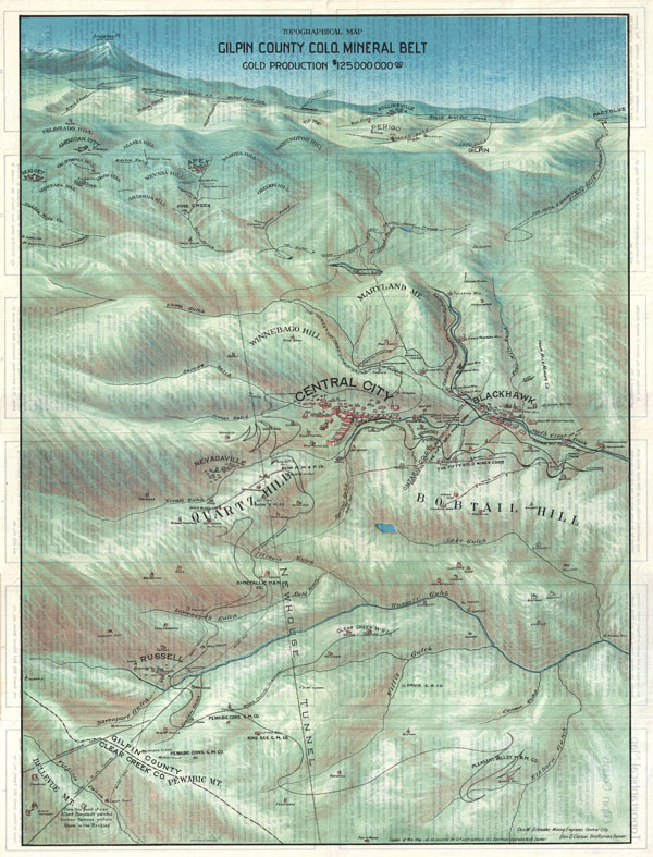
George Samuel Clason (November 7, 1874 - 1957) was born in the city of Louisiana, Missouri in 1874. As a young man, Clason studied at the University of Nebraska before joining the United States Army in 1898 to fight in the Spanish American War. After the war, he moved to Denver, Colorado where in 1905 he founded the Clason Map Company, thus starting his lucrative publishing career. Clason initially focused on mining and mineral maps - capitalizing on the Colorado and Nevada mining industry, but quickly transitioned to railroad maps, city maps, and by the 1920s, road maps. As the company expanded, Clason opened a secondary office in Chicago, Illinois - then a rising map publishing center and railroad hub. At least one other satellite office was opened in Los Angeles. Among his many achievements, Clason is credited with producing the first modern road atlas of the United States. In the late 1920s, Clason also published a series of get-rich-quick pamphlets in the form of parables. The most famous of these is The Richest Man in Babylon. This tells the story of Arkad, a citizen of Babylon famed for his great wealth and generosity who shares his wit and wisdom with his fellow Babylonians. In 1949, Clason moved to Napa, California to retire and found a social club for retired gentlemen. More by this mapmaker...

Condition


Very good condition. Original folds. Text on verso.

References


Beinecke Library, BrSides Zc49 906sc.