This item has been sold, but you can get on the Waitlist to be notified if another example becomes available, or purchase a digital scan.
1892 Rand McNally Map of Greece and the Archipelago
Greece-randmcnally-1895$37.50

Title
Map of Greece.
1892 (dated) 13 x 20 in (33.02 x 50.8 cm) 1 : 1470000
1892 (dated) 13 x 20 in (33.02 x 50.8 cm) 1 : 1470000
Description
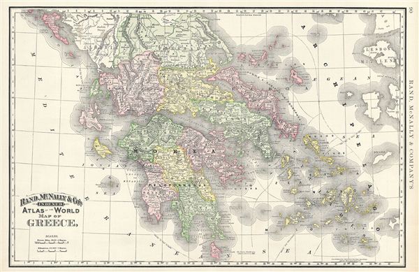
This is a beautiful example of Rand McNally and Company's 1892 map of Greece. It covers from Corfu to Cythera and includes the Cyclades. Although Greece gained independence from the Ottoman empire in 1832 under the Treaty of Constantinople, it would go on to wage war against the empire in 1897 for control over Crete. The Greeks lost the war and some border territories. The intervention of the great powers, however led to Cretan independence and its subsequent consolidation with Greece in 1908. Color coded according to regions and territories, the map notes several towns, cities, rivers and various other topographical details with relief shown by hachure. This map was issued as plate no. 90 in the 1895 issue of Rand McNally and Company's Indexed Atlas of the World - possibly the finest atlas Rand McNally ever issued.
Cartographer
Rand, McNally and Co. (fl. 1856 - present) is an American publisher of maps, atlases and globes. The company was founded in 1856 when William H. Rand, a native of Quincy, Massachusetts, opened a print shop in Chicago. Rand hired the recent Irish immigrant Andrew McNally to assist in the shop giving him a wage of 9 USD per week. The duo landed several important contracts, including the Tribune's (later renamed the Chicago Tribune) printing operation. In 1872, Rand McNally produced its first map, a railroad guide, using a new cost effective printing technique known as wax process engraving. As Chicago developed as a railway hub, the Rand firm, now incorporated as Rand McNally, began producing a wide array of railroad maps and guides. Over time, the firm expanded into atlases, globes, educational material, and general literature. By embracing the wax engraving process, Rand McNally was able to dominate the map and atlas market, pushing more traditional American lithographic publishers like Colton, Johnson, and Mitchell out of business. Eventually Rand McNally opened an annex office in New York City headed by Caleb S. Hammond, whose name is today synonymous with maps and atlases, and who later started his own map company, C. S. Hammond & Co. Both firms remain in business. More by this mapmaker...
Source
Rand McNally & Co., Foreign Countries. Rand, McNally & Co's Indexed Atlas of the World (Complete in Two Volumes)…, (Chicago) 1895.
Condition
Very good. Text on verso.
References
Rumsey 3565.022 (1897 edition). Philip (atlases) 1026 (1898 edition).