This item has been sold, but you can get on the Waitlist to be notified if another example becomes available, or purchase a digital scan.
1652 Sanson Map of India
India-sanson-1652$165.00

Title
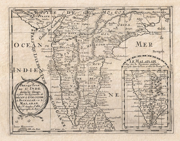
Presqu'Isle de L'Inde deca le Gange, ou sont les Royaumes de Decan, de Golconde, de Bisnagar, et le Malabar.
1652 (undated) 8 x 10 in (20.32 x 25.4 cm)
1652 (undated) 8 x 10 in (20.32 x 25.4 cm)
Description
A small but attractive 1652 map of India by the French cartographer Nicholas Sanson. Covers the subcontinent From the Bay of Bengal and the Gulf of Cambay to Ceylon (Sri Lanka). Offers impressive detail given that the interior of India was largely unknown to the west until the British survey's of the late 18th century. The vast Mogul Empire sprawls across the northern part of the map. Further south the kingdoms of Deccan, Malabar, Bisnagar, and Golconda, among others, are noted. As an indicator of how just out of date European knowledge of this region was, most of these kingdoms had fallen to ruin over 100 years prior to the publication of this map. The Portuguese enclave of Goa on India's west coast is noted. In the lower right quadrant there is an inset of the Malabar Coast. The lower left hand quadrant features a curious and speculative depiction of the Maldives.
Cartographer
Nicolas Sanson (December 20, 1600 - July 7, 1667) and his descendants were the most influential French cartographers of the 17th century and laid the groundwork for the Golden Age of French Cartography. Sanson was born in Picardy, but his family was of Scottish Descent. He studied with the Jesuit Fathers at Amiens. Sanson started his career as a historian where, it is said, he turned to cartography as a way to illustrate his historical studies. In the course of his research some of his fine maps came to the attention of King Louis XIII who, admiring the quality of his work, appointed Sanson Geographe Ordinaire du Roi. Sanson's duties in this coveted position included advising the king on matters of geography and compiling the royal cartographic archive. In 1644, he partnered with Pierre Mariette, an established print dealer and engraver, whose business savvy and ready capital enabled Sanson to publish an enormous quantity of maps. Sanson's corpus of some three hundred maps initiated the golden age of French mapmaking and he is considered the 'Father of French Cartography.' His work is distinguished as being the first of the 'Positivist Cartographers,' a primarily French school of cartography that valued scientific observation over historical cartographic conventions. The practice result of the is less embellishment of geographical imagery, as was common in the Dutch Golden Age maps of the 16th century, in favor of conventionalized cartographic representational modes. Sanson is most admired for his construction of the magnificent atlas Cartes Generales de Toutes les Parties du Monde. Sanson's maps of North America, Amerique Septentrionale (1650), Le Nouveau Mexique et La Floride (1656), and La Canada ou Nouvelle France (1656) are exceptionally notable for their important contributions to the cartographic perceptions of the New World. Both maps utilize the discoveries of important French missionaries and are among the first published maps to show the Great Lakes in recognizable form. Sanson was also an active proponent of the insular California theory, wherein it was speculated that California was an island rather than a peninsula. After his death, Sanson's maps were frequently republished, without updates, by his sons, Guillaume (1633 - 1703) and Adrien Sanson (1639 - 1718). Even so, Sanson's true cartographic legacy as a 'positivist geographer' was carried on by others, including Alexis-Hubert Jaillot, Guillaume De L'Isle, Gilles Robert de Vaugondy, and Pierre Duval. More by this mapmaker...
Source
Sanson D'Abbeville, Nicolas, L'Asie en Plusieurs Cartes & En Divers Traitez De Geographie, Et D'Histoire…, Paris: Chez l'auteur, 1652.
Condition
Very good condition. Overall toning. Wide clean margins. Crisp dark impression.
References
Rajendra, The Art of Map-Making and Some Rare Maps of South Asia and Sindh 140 AD to 1808 AD, no. 16.