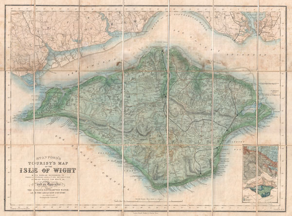
An uncommon 1879 pocket map of the Isle of Wight prepared by Edward Stanford. Covers the entire island as well as adjacent parts of Hampshire across the Solent Spithead. Wight is known for its unusual geology and ancient fossil's. This map attempts to locate likely locations for fossil hunting as well the sites of various antiquities and island communities. A geological overview of the region appears in an inset in the lower right quadrant.
Though most maps are without substantial provenance, this map is known to have been originally purchased for the European tour of the prominent 19th century New Yorker Andrew Haswell Green (1820 - November 13, 1903). A. H. Green was a New York lawyer, city planner, civic leader and agitator for reform. Called by some historians a hundred years later 'the 19th century Robert Moses,' he held several offices and played important roles in many New York projects, including the development of Riverside Drive, Morningside Park, Fort Washington Park, and Central Park. His last great project was the consolidation of the 'Imperial City' or 'City of Greater New York' from the earlier cities of New York, Brooklyn and Long Island City, and still largely rural parts of Westchester, Richmond and Queens Counties. In 1903 Green was murdered in a case of mistaken identity. He is buried in Worcester. In 1905 his family estate in Worchester was turned into a public park. Green's personal effects and other belongings were stored for over 100 years until recently being rediscovered and offed for sale.
Cartographer
Edward Stanford (May 27, 1827 - November 3, 1904) was one of the most prolific map publishing firms of the late 19th century. The company began as a partnership in 1848 between the 21 year old Edward Stanford and the established map dealer Trelawney Saunders. By 1853 the partnership had dissolved and Edward Stanford took full control of the business. A subsequent series of expansions and exciting new map issues finally led to the production of Stanford's masterwork, "Stanford's Library Map of London". This map is still available and remains somewhat accurate. At the time of publishing it was hailed by the Royal Geographical Society as "the most perfect map of London that has ever been issued". In 1882 Edward Stanford Sr. passed the firm on to his son, Edward Stanford Jr. who continued in his father's proud tradition. Today the Stanford firm still publishes maps and remains one of the most important and prolific cartographic publishers in the world. More by this mapmaker...
Very good. Attached to original linen though the adhesions is very weak and has come loose in some places. Light soiling. Comes with original linen binder. Else very nice.