This item has been sold, but you can get on the Waitlist to be notified if another example becomes available, or purchase a digital scan.
1764 Bellin Map of the Virgin Islands in the West Indies
IslesDesVierges-bellin-1764$337.50

Title
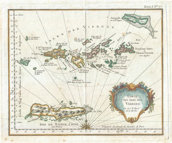
Carte des Isles des Vierges.
1764 (undated) 8.5 x 10.5 in (21.59 x 26.67 cm) 1 : 80000
1764 (undated) 8.5 x 10.5 in (21.59 x 26.67 cm) 1 : 80000
Description
This is an extremely scarce 1764 map of the Virgin Islands in the Caribbean Sea by Jacques-Nicolas Bellin. It covers the Virgin Islands and the British Virgin Islands including St. Croix, St. Thomas, St. John, Tortola, Virgin Gorda and Anegada Islands, and others. The map is beautifully detailed, noting topographical and coastal features, forts, mountains etc. A beautiful decorative title cartouche is included in the lower right quadrant of the map. All maps specific to the Virgin Islands very rarely appear on the market, making this a rare opportunity. This map was published in 1764 by Jacques-Nicolas Bellin for inclusion in his Le Petit Atlas Maritime.
Cartographer
Jacques-Nicolas Bellin (1703 - March 21, 1772) was one of the most important cartographers of the 18th century. With a career spanning some 50 years, Bellin is best understood as geographe de cabinet and transitional mapmaker spanning the gap between 18th and early-19th century cartographic styles. His long career as Hydrographer and Ingénieur Hydrographe at the French Dépôt des cartes et plans de la Marine resulted in hundreds of high quality nautical charts of practically everywhere in the world. A true child of the Enlightenment Era, Bellin's work focuses on function and accuracy tending in the process to be less decorative than the earlier 17th and 18th century cartographic work. Unlike many of his contemporaries, Bellin was always careful to cite his references and his scholarly corpus consists of over 1400 articles on geography prepared for Diderot's Encyclopedie. Bellin, despite his extraordinary success, may not have enjoyed his work, which is described as "long, unpleasant, and hard." In addition to numerous maps and charts published during his lifetime, many of Bellin's maps were updated (or not) and published posthumously. He was succeeded as Ingénieur Hydrographe by his student, also a prolific and influential cartographer, Rigobert Bonne. More by this mapmaker...
Source
Bellin, J. N., Le Petit Atlas Maritime, 1764.
Condition
Very good. Original platemark visible. Minor spotting at places. Minor wear and toning along original centerfold.
References
Phillips (Atlases) 3508.