This item has been sold, but you can get on the Waitlist to be notified if another example becomes available, or purchase a digital scan.
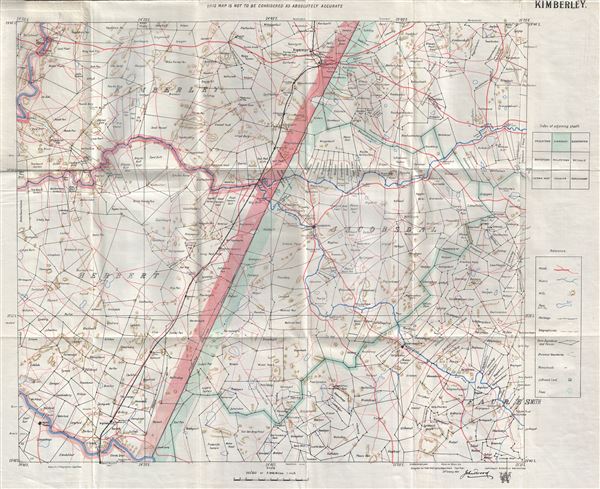
1900 John Wood Map of Kimberley, South Africa
Kimberley-johnwood-1900$50.00

Title
Kimberley.
1900 (dated) 19.5 x 24.5 in (49.53 x 62.23 cm) 1 : 250000
1900 (dated) 19.5 x 24.5 in (49.53 x 62.23 cm) 1 : 250000
Description
This is a fine 1900 map of Kimberley and vicinity, South Africa by John I Wood. Centered on Jacobsdal, it covers from Kimberley to Fauresmith. Compiled for the Field Intelligence Department, Cape Town, this map 'is not to be considered as absolutely accurate,' as mentioned in the top margin. It notes roads, rivers, hills, pans, railways, trees, boundaries and other topographical features.
This map was made when the region was in the midst of the Second Boer War or the Anglo-Boer War. Fought between the British Empire and the independent Boer republics of the Orange Free State and the Transvaal Republic from October 1899 to May 1902. It would end with the Treaty of Vereeniging, and British sovereignty over the two Boer republics. This map was printed by Argus Company in Cape Town compiled for the Field Intelligence Department, Cape Town on 20th January 1900, by John I. Wood.
This map was made when the region was in the midst of the Second Boer War or the Anglo-Boer War. Fought between the British Empire and the independent Boer republics of the Orange Free State and the Transvaal Republic from October 1899 to May 1902. It would end with the Treaty of Vereeniging, and British sovereignty over the two Boer republics. This map was printed by Argus Company in Cape Town compiled for the Field Intelligence Department, Cape Town on 20th January 1900, by John I. Wood.
Condition
Very good. Minor wear along original fold lines. Backed by linen. Folds into original cardboard binder.