This item has been sold, but you can get on the Waitlist to be notified if another example becomes available, or purchase a digital scan.
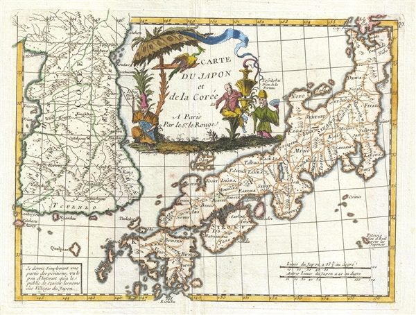
1748 Le Rouge Map of Korea and Japan
KoreaJapan-lerouge-1848$200.00

Title
Carte du Japon et de la Corée.
1748 (undated) 9 x 11.5 in (22.86 x 29.21 cm) 1 : 3770000
1748 (undated) 9 x 11.5 in (22.86 x 29.21 cm) 1 : 3770000
Description
An attractive 1748 map of Korea and Japan dawn by George Louis Le Rouge. The map covers both Korea and Japan in full and features a large central cartouche occupying the 'Sea of Korea' / 'Sea of Japan' region, although neither term us used. Korea is drawn following upon the 1737 D'Anville model. Both countries are loosely divided into provinces with major cities named. Topography is present but vague. Publisehd in Le Rouge's 1748 Atlas Nouveau Portative
Cartographer
Georges-Louis Le Rouge (c. 1707 - c. 1790) was a Paris based map publisher operating in the middle part of the 18th century. Le Rouge was born in Hanover Germany as Georg Ludwig, where he was educated and employed as a military engineer and surveyor. His father may have been the French architect Louis Remy de la Fosse (1659 - 1726), which would explain his early education in both engineering and draftsmanship. He assisted his father on a large-scale plan of Darmstadt, which he completed following his father's death in 1726. He may have remained in Darmstadt, but little is known of his life from 1726 - 1736, when he appears in Paris. Le Rouge acquired a position as military and civil engineer for King Louis XV and Louis XVI. Around this time, he Francophied his name to 'Le Rouge'. In 1840, he set up shop on the Rue Des Grands Augustins as an engraver, book publisher, and map publisher. He partnered with the English cartographer and engineer John Rocque (1709 - 1762), who became an important source for English maps, which Le Rouge re-engraved for French use. Despite being born German and adopting Paris as his home, Le Rouge was an ardent Anglophile and spent much of his time translating English books and maps into French. During his active period of roughly forty years Le Rouge produced thousands of maps and diagrams ranging from city and town plans, to atlases, plans of military campaigns and sea charts. He was a friend and correspondent of Benjamin Franklin (1706 - 1790), with whom he produced the important 1769 Franklin/Folger Map of the Gulf Stream. Franklin, who met Le Rouge in Paris, writes that 'He [Le Rouge] is, I believe, a proper person.' He was awarded for his diligence with the impressive but unstipended honorific 'Geographe du Roi'. They may not have served him swell during the French Revolution (1789 - 1799), as his last known work was published in 1789, just before the storming of the Bastille. The exact date of Le Rouge's death remains a mystery. By most estimates, he is believed to have been alive in 1790, but may have lived as long as 1794. More by this mapmaker...
Source
Le Rouge, George Louis, Atlas Nouveau Portatif à l'usage des Militaires et du Voyageur contenant 91 Cartes dressées sur les nouvelles Observations dédié à Monseigneur le Comte de Maurepas, Ministre et Secrétaire d'Etat, (Paris) 1748.
Condition
Very good. Minor wear along original fold lines. Original platemark visible.