This item has been sold, but you can get on the Waitlist to be notified if another example becomes available, or purchase a digital scan.
1936 Showa 11 Panoramic Map View of Korea
KoreaPanorama-showa11-1936$125.00

Title
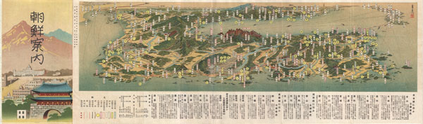
Railroad Map of Korea.
1936 or Showa 11 (dated) 7 x 24 in (17.78 x 60.96 cm)
1936 or Showa 11 (dated) 7 x 24 in (17.78 x 60.96 cm)
Description
An extremely attractive 1936 or Showa 11 panoramic view map of Korea. This uncommon type of map evolved out of traditional Japanese view-style cartography and began to appear in Japan, Taiwan, and Korea in the early 20th century. Generally speaking such maps coincided with the development of railroad lines throughout the once vast Dai Nippon Teikoku or Japanese Empire. It is a distinctive style full of artistic flourish that at the same time performs a practical function. This particular example is both relatively early and exceptionally beautiful. It was printed via a multi-color lithographic process with delicate subdued tones and a easily comprehensible intuitive design. Oriented to the northeast Korea appears in the foreground with major cities and notable geological formations exaggerated in proportion. In the background we can see parts of Japan and Manchuria. In addition to rail lines, roadways and seaways are noted. Folds into itself, accordion style, with an art deco style cover depicting Seoul at the left end. Verso features additional Japanese text, a smaller map, and nine photographs showing off the people and country of Korea.
Condition
Very good. Minor wear on original fold lines, else clean. Text and photographs on verso.