This item has been sold, but you can get on the Waitlist to be notified if another example becomes available, or purchase a digital scan.
1730 Seutter Map of Turkey (Ottoman Empire), Persia and Arabia
MagniTurcarum-seutter-1740$250.00

Title
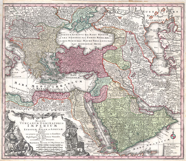
MAGNI TURCARUM DOMINATORIS IMPERIUM per EUROPAM, ASIAM ET AFRICAM, se extendens Regiones tam proprias, quan tributarias et clientelares ut et omnes Beglerbegatus sive Praefecturas Generales oculis sistens accuratissima cura delineatum per MATTHAEUM SEUTTER, S.C. Maj. Geogr. Aug.
c. 1730 (undated) 20 x 23 in (50.8 x 58.42 cm)
c. 1730 (undated) 20 x 23 in (50.8 x 58.42 cm)
Description
A spectacular c. 1730 map of the Ottoman Empire, including Greece, Turkey, Persia, Egypt and Arabia, by the important Augsburg map publisher Gerog Matthaus Seutter. Depicts from Italy eastward to the Caspian Sea, which is depicted in its entirety. Includes Crimea and the Caucuses: Georgia, Circassia and Armenia. Extends south to include all of Arabia and the northern tip of the Horn of Africa. Generally accurate with a few cartographic anomalies. The Dead Sea is over-large and misshapen. A large and nonexistent lake appears just west of the Nile Delta. In the lower left hand quadrant there is a large decorative title cartouche attributed to the Augsburg silversmith Abraham Drentwet. Depicts the ottoman Emperor gloriously robed with and enthroned. On the ground before him two men bow and offer hum treasures. The images on the right of the title offer a more allegorical references and include an European holding a globe, a lion, the Rod of Asclepius, a Medusa head shield and s spear. Angels with trumpets look on from above. A map key appears in the lower right quadrant. Cartographically similar to Visscher's 1690 map of the same area. This is a rather unusual state of the map and one of the few examples wherein 'S.G. Maj Geogr. Aug' follows Seutter's name in the title cartouche. The only comparable example we have found is in the British Museum.
CartographerS
Matthäus Seutter (1678 - 1757) was one of the most important and prolific German map publishers of the 18th century. Seutter was born the son of a goldsmith but apprenticed as a brewer. Apparently uninspired by the beer business, Seutter abandoned his apprenticeship and moved to Nuremberg where he apprenticed as an engraver under the tutelage of the prominent J. B. Homann. Sometime in the early 1700s Seutter left Homann to return to Augsburg, where he worked for the prominent art publisher Jeremiad Wolff (1663 - 1724), for whom he engraved maps and other prints. Sometime around 1717 he established his own independent cartographic publishing firm in Augsburg. Though he struggled in the early years of his independence, Seutter's engraving skill and commitment to diversified map production eventually attracted a substantial following. Most of Seutter's maps are heavily based upon, if not copies of, earlier work done by the Homann and De L'Isle firms. Nonetheless, by 1731/32 Seutter was one of the most prolific publishers of his time and was honored by the German Emperor Karl VI who gave him the title of Imperial Geographer, after which most subsequent maps included the Avec Privilege designation. Seutter continued to publish until his death, at the height of his career, in 1757. Seutter had two engraver sons, Georg Matthäus Seutter (1710 - 173?) and Albrecht Carl Seutter (1722 - 1762). Georg Matthäus quit the business and relocated to Woehrdt in 1729 (and probably died shortly thereafter), leaving the family inheritance to his wastrel brother Albrecht Carl Seutter, who did little to advance the firm until in own death in 1762. Following Albrecht's death, the firm was divided between the established Johann Michael Probst (1727 - 1776) firm and the emerging firm of Tobias Conrad Lotter. Lotter, Matthäus Seutter's son-in-law, was a master engraver and worked tirelessly on behalf of the Suetter firm. It is Lotter, who would eventually become one of the most prominent cartographers of his day, and his descendants, who are generally regarded as the true successors to Matthäus Seutter. (Ritter, M. Seutter, Probst and Lotter: An Eighteenth-Century Map Publishing House in Germany., "Imago Mundi", Vol. 53, (2001), pp. 130-135.) More by this mapmaker...
Abraham Drentwett (1647 - 1729) was an important Ausgsburg artist and silversmith. He is best known for his master silverwork, much of which survives today. Drentwett was occasionally employed by Matthaus Seutter and other Augsburg engravers to create decorative embellishments and cartouches. Learn More...
Source
Atlas Novus. Matthaeso Seutter. (1730)
Condition
Very good condition. Narrow margins on right and left extended. Blank on verso. Original centerfold.
References
Phillips 593. Tibbetts, G. R., Arabia in Early Maps: A Bibliography of Maps Covering the Peninsula of Arabia, Printed in Western Europe from the Invention of Printing to the Year 1751, #248. British Museum, Map Collections ; Maps * 43305.(6.).