1854 Mitchell Map of Maine
Maine-mitchell-1854$150.00

Title
A New Map of Maine.
1854 (dated 1850) 16 x 13 in (40.64 x 33.02 cm)
1854 (dated 1850) 16 x 13 in (40.64 x 33.02 cm)
Description
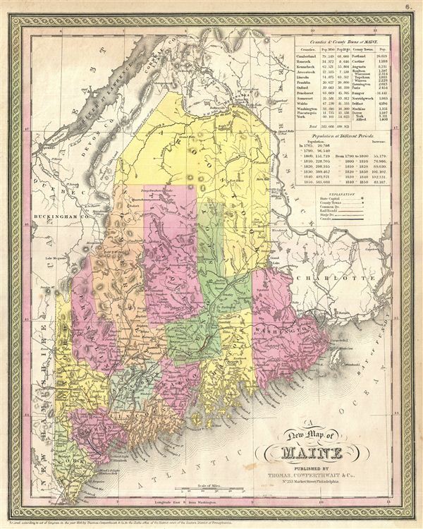
A beautiful and delicate example of S. A. Mitchell's 1854 New Map of Maine. This rare map covers the entire state of Maine from the New Hampshire border to Passamaquoddy Bay, and northwards as far as the St. John's River. In the upper right quadrant an inset offers population data according the various censuses to 1850 in tabular format. The whole is engraved and colored in Mitchell's distinctive style with green border work and vivid pastels. Political and topographical features are noted and color coded with elevation rendered by hachure.
After Maine became a state, carved out of Massachusetts in 1820, the northern boundary was disputed between the U.S. and Canada. The King of the Netherlands was appointed arbiter and settled the dispute with a new border of his own imagining. The first edition of this map issued in 1846, shortly after the 1842 treaty established the new Maine-Canada border – hence the map's title, 'A New Map of Maine.' This map shows several borders, including the post-Revolutionary War border of 1783, the line proposed by the King of the Netherlands, and, ceding slightly more land to Canada, the final 1842 boundary.
This map was prepared by S. A. Mitchell for publication by the Philadelphia firm of Thomas Cowperthwait & Co. as plate no. 6 in the 1854 edition of Mitchell's New General Atlas. According to Thomson this is state 21 of this map, varying over the previous states with regard to a corrected mapping of Old Town, in Penobscot County. Dated and copyrighted, 'Entered according to act of Congress in the year 1850 by Thomas Cowperthwait & Co. in the Clerk's office of the Eastern District of Pennsylvania.'
Samuel Augustus Mitchell (March 20, 1792 - December 20, 1868) began his map publishing career in the early 1830s. Mitchell was born in Bristol, Connecticut. He relocated to Philadelphia in 1821. Having worked as a school teacher and a geographical writer, Mitchell was frustrated with the low quality and inaccuracy of school texts of the period. His first maps were an attempt to rectify this problem. In the next 20 years Mitchell would become the most prominent American map publisher of the mid-19th century. Mitchell worked with prominent engravers J. H. Young, H. S. Tanner, and H. N. Burroughs before attaining the full copyright on his maps in 1847. In 1849 Mitchell either partnered with or sold his plates to Thomas, Cowperthwait and Company who continued to publish the Mitchell's Universal Atlas. By about 1856 most of the Mitchell plates and copyrights were acquired by Charles Desilver who continued to publish the maps, many with modified borders and color schemes, until Mitchell's son, Samuel Augustus Mitchell Junior, entered the picture. In 1859, S.A. Mitchell Jr. purchased most of the plates back from Desilver and introduced his own floral motif border. From 1860 on, he published his own editions of the New General Atlas. The younger Mitchell became as prominent as his father, publishing maps and atlases until 1887, when most of the copyrights were again sold and the Mitchell firm closed its doors for the final time. Learn More...
Source
Mitchell, S. A., A New Universal Atlas Containing Maps of the various Empires, Kingdoms, States and Republics Of The World, (Thomas Cowperthwait & Co., Philadelphia) 1854.
Condition
Very good condition. Blank on verso.
References
Rumsey 4557.008 (1846 edition) Phillips (Atlases) 814.