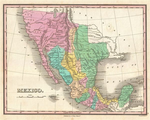
A scarce and important 1827 map of Mexico by Anthony Finley. Covers from upper California and New Albion south to Guatemala, including the modern day regions of California, New Mexico, Arizona, Colorado, Utah, Nevada, Texas and Mexico. Offers an interesting pre-Republic mapping of Texas folded into the Intendency of San Louis Potosi. Here New Mexico, previously a vast territory, is limited to a narrow sliver of land attached to the upper Rio Norte or Rio Grande.
Further west this map really gets interesting with the explorations of Escalante and Humboldt very much in evidence. Finley curiously charts two lakes in the Great Basin, one labeled Timpanagos and another smaller lake further south labeled 'Salt Lake.' The Great Salt Lake is said to have first been seen by Europeans in 1824, only a few years before this map was published, so it is unlikely that Finley drew from this exploration. Instead, Finely is following Escalante's discoveries as recorded on the Miera map. The Escalante expedition actually visited Utah Lake (Timpanagos), but only heard about the Great Salt Lake from local Native American Ute tribe. Miera, Escalante's cartographer, thus mapped Timpanagos as much larger than the unseen 'Great Salt Lake.'
Finley also maps the Buenaventura River running from the Rocky Mountains westward through 'Salt Lake' and westward to San Francisco Bay. The Buenaventura is the last incarnation of the apocryphal River of the West, a long sought after speculative alternative to the Northwest Passage. The mapping of Buenaventura here again references legitimate discoveries by Escalante of the White River and the Sevier River. In this case, both are mistakenly associated with the River of the West and given an erroneous outlet into San Francisco Bay.
In addition to geographical notations, Finley also identifies a number of American Indian nations including the Moqui, Apache, Juma, Nochi, Poagos and Yahipias (with long beards). Engraved by Young and Delleker for the 1827 edition of Anthony Finley's General Atlas.
Cartographer
Anthony Finley (August 25, 1784 - June 9, 1836) was an American book and map publisher based in Philadelphia, Pennsylvania. Finley was born in Philadelphia in 1874. He opened a bookshop and publishing house at the Northeast corner of Fourth and Chestnut Street, Philadelphia in 1809. His earliest known catalog, listing botanical, medical and other scientific works, appeared in 1811. His first maps, engraved for Daniel Edward Clarke’s Travels in Various Countries of Europe, Asia, and Africa also appear in 1811. His first atlas, the Atlas Classica, was published in 1818. He soon thereafter published the more significant A New American Atlas and the New General Atlas…, both going through several editions from 1824 to 1834. Although most of Finley's cartographic material was borrowed from European sources, his atlases were much admired and favorably reviewed. In addition to his work as a printer, Finley ran unsuccessfully on the 1818 Democratic ticket for Philadelphia Common Council. He was a founding officer of the Philadelphia Apprentices’ Library, and a member of both the American Sunday-School Union and the Franklin Institute. He was also an ardent supporter of the American Colonization Society, an organization dedication to returning free people of color to Africa - which led to the founding of Liberia. Much of his wealth was dedicated to supporting this cause. Finley was active as a publisher until his 1836 death, apparently of a 'lingering illness.' Shortly thereafter advertisements began appearing for his map business and plates, most of which were acquired by Samuel Augustus Mitchell. More by this mapmaker...
Source
Finley, Anthony, A New General Atlas, Comprising a Complete Set of Maps, representing the Grand Divisions of the Globe, Together with the several Empires, Kingdoms and States in the World; Compiled from the Best Authorities, and corrected by the Most Recent Discoveries, Philadelphia, 1827.
Very good condition. Original platemark visible. Blank on verso.
Rumsey 0285.032 (1831 edition). Phillips (Atlases) 4314-31. Day, J. M., Maps of Texas, 1572 - 1900: The Map Collection of the Texas State Archives, 1470A, 1505.