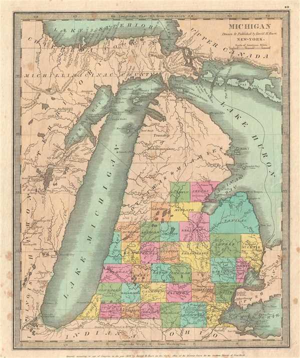
A very attractive and rare 1835 first edition example of Burr's map of Michigan, including Lake Michigan in full. Burr's map covers from the southern shores of Lake Superior to the Indiana / Ohio border and from Chicago to Lake St. Clair, covering thus the state of Michigan, c. 1831, in full.
Features a distinctive narrow drawn out configuration of Lake Michigan based upon Aaron Arrowsmith's map of 1802. This configuration would be copied in various atlases until about 1840 when more sophisticated surveys of Lake Michigan became available.
The northern parts of the state are loosely organized into various first nation territories. The 'Ottawas' and 'Miamies' are identified as is the 'Township of Michillimacinac.' The upper peninsula is divided between Michillimacinac County and Chippewa County. The western shore of Lake Michigan, roughly from Green Bay to Brochais River, is identified as Huron Territory. Throughout these lands American Indian villages are identified with both care and precision.
At the southern tip of Green Bay, Fort Howard and the settlement of Green Bay is noted. This area was settled extensively by New England farmers following the 1832 end of the Black Hawk War, making this one of the earliest maps to delineate the Green Bay's borders.
At the southern tip of Michigan Burr notes a territorial dispute between Michigan an Indiana. Michigan claimed territory extending far enough south to include the entire eastern shore of Lake Michigan. This territory was in fact part of the original Michigan charter as of 1805. When Indiana applied for statehood in 1816, Territory Delegate Jonathan Jennings proposed the border be moved further north to give Indiana a port on Lake Michigan – then a major artery of trade.
A similar dispute further east had just been resoled between Michigan and Ohio. Again, according to the original 1805 Michigan charter, the border extended well south of the present location. This led to the Toledo War or Michigan-Ohio War of 1835 – 1836, which ultimately resolved the issue in the favor of Ohio. Ohio thus gained control of the Toledo Strip and Michigan, in exchange, received part of the Upper Peninsula. Of course, none of these events had occurred when this map was printed, and so here, Burr has decided in favor of Michigan with enough conviction that he does not even bother to acknowledge the dispute.
This is the 1835 first edition of this important map which has become quite scarce. It was copyrighted in 1831 by David H. Burr, but not published until the atlas was released in 1835.
CartographerS
David Hugh Burr (August 18, 1803 - December 25, 1875) of one of the first and most important truly American cartographers and map publishers. Burr was born in Bridgeport Connecticut in August of 1803. In 1822 Burr moved to Kingsboro, New York to study law. A year and a half later he was admitted to the New York Bar association. Burr must have questioned his choice of careers because shortly after being admitted to the Bar, he joined the New York State Militia. Though largely untrained in the art of surveying, Burr was assigned to work under Surveyor General of New York, Simeon De Witt, to survey several New York Roadways. Seeing a window of opportunity, Burr was able to negotiate with the governor of New York at the time, De Witt Clinton, to obtain copies of other New York survey work in order to compile a map and Atlas of the state of New York. Recognizing the need for quality survey work of its territory, the government of New York heartily endorsed and financed Burr's efforts. The resulting 1829 Atlas of the State of New York was the second atlas of an individual U.S. state and one of the most important state atlases ever produced. Burr went on to issue other maps both of New York and of the United States in general. In cooperation with publishing firm of Illman & Pillbrow, he produced an important New Universal Atlas and, with J.H. Colton, several very important maps of New York City. In recognition of this work, Burr was appointed both "Topographer to the Post office" and "Geographer to the House of Representatives of the United States". Later, in 1855, Burr was assigned to the newly created position of Surveyor General to the State of Utah. Burr retired from the position and from cartographic work in general in 1857 when light of some of his financial misdeeds and frauds came to light. He was accused of submitting false expense reports and underpaying employees, among other indiscretions. More by this mapmaker...
Thomas Illman (fl. c. 1824 – 1858) was an English engraver active in New York City during the early 19th century. Illman was born in England and attended Trinity College in Oxford where he attained a degree in theology. Despite initial religious fervor, he soon became an atheist. Professionally he turned to engraving to support his artistic tendencies. In London he mastered the engraver's art. His first paying work as an artist was illustrating for Thomas Carlyle's Confessions of an English Opium Eater. He relocated to New York City in 1828, almost immediately partnering with Edward Pilbrow to found the firm Illman and Pilbrow. Illman and Pillbrow were almost immediately hired by David H. Burr to engrave maps for his Universal Atlas, which he began working on in that year. When Burr took a position as topographer and cartographer for the United States Post Office, he ceded all remaining work on the Atlas to Illman and Pilbrow. In addition to his atlas work, Illman privately pursued his own art as well as engraved portraits and landscapes. He was admired as a skilled line, stipple, and mezzotint engraver. At some point he may have relocated to Philadelphia. His sons, H. Illman and G. Illman followed in his footsteps founding Illman Sons in 1845
Learn More...
Source
Burr, David H., A New Universal Atlas; Comprising Separate Maps of All the Principal Empires, Kingdoms & States Throughout the World: and forming a distinct Atlas of the United States, (New York: D. S. Stone) 1835 (First Edition).
Burr's New Universal Atlas was first published in 1835. It is one of the first great American commercial atlases and one of the most important to appear before the Civil War. Burr was most likely initially inspired to publish a 'universal atlas' in pursuit a more general audience by the success of his 1829 Atlas of New York State. He began work on the Universal Atlas sometime around 1830. By 1832 he had copyrighted eight new maps for the work. Around this time he accepted a position as topographer and cartographer for the United States Postal Department and was thus unable to finish the atlas personally. Instead, while retaining editing rights and overall ownership, Burr passed much of the production work to his engravers Thomas Illman and Edward Pillbrow. The first edition of the atlas was completed in 1835 and published by D. S. Stone of New York. A second edition, published by William Hall, appeared in the following year, 1836. Both editions featured 63 maps, the first part of the book being dedicated to world maps and the second part to the Americas, particularly the United States. Some of 1836 editions features outline rather than the distinctive full color common in the first edition. The plates for the atlas were later sold to Jeremiah Greenleaf who expanded the atlas to 65 maps and issued editions in 1840, 1842, and 1848.
Good. Some marginal spotting. Original platemark visible. Blank on verso. Bright old color.
Rumsey 4628.044. Karpinski, L. C., Bibliography of the Printed Maps of Michigan, 1804-1880, no. 111.