This item has been sold, but you can get on the Waitlist to be notified if another example becomes available, or purchase a digital scan.
1826 Finley Comparative Map of the Principle Mountains of the World
Mountains-finley-1827$125.00

Title
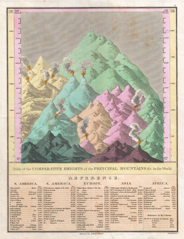
Table of the Comparative Heights of the Principal Mountains & c. in the World.
1827 (undated) 11.5 x 9 in (29.21 x 22.86 cm)
1827 (undated) 11.5 x 9 in (29.21 x 22.86 cm)
Description
This is Finley's highly sought after c. 1827 map of the comparative heights of the principal mountains of the world. Details the world's great mountains in relative proximity to one another and divided by continent. Each mountain is numbered and refers to a reference list below the chart proper, which names each mountain and its elevation. Also notes important cities, mines, volcanoes and geographical locations, including the Great Pyramid. When this chart was map the highest mountain North America was considered to be Mexico's Popocatepetl, in South America it was Chimborazo, in Europe Mont Blanc, in Asia Dhaulagiri, and in Africa the Atlas Mountains of Morocco. Predates the discovery of Mt. Everest, Mt. Kilimanjaro, Mt. Kenya, and Mt. McKinley (Denali). Engraved by Young and Delleker for the 1827 edition of Anthony Finley's General Atlas.
Cartographer
Anthony Finley (August 25, 1784 - June 9, 1836) was an American book and map publisher based in Philadelphia, Pennsylvania. Finley was born in Philadelphia in 1784. He opened a bookshop and publishing house at the Northeast corner of Fourth and Chestnut Street, Philadelphia in 1809. His earliest known catalog, listing botanical, medical and other scientific works, appeared in 1811. His first maps, engraved for Daniel Edward Clarke’s Travels in Various Countries of Europe, Asia, and Africa also appear in 1811. His first atlas, the Atlas Classica, was published in 1818. He soon thereafter published the more significant A New American Atlas and the New General Atlas…, both going through several editions from 1824 to 1834. Although most of Finley's cartographic material was borrowed from European sources, his atlases were much admired and favorably reviewed. In addition to his work as a printer, Finley ran unsuccessfully on the 1818 Democratic ticket for Philadelphia Common Council. He was a founding officer of the Philadelphia Apprentices’ Library, and a member of both the American Sunday-School Union and the Franklin Institute. He was also an ardent supporter of the American Colonization Society, an organization dedication to returning free people of color to Africa - which led to the founding of Liberia. Much of his wealth was dedicated to supporting this cause. Finley was active as a publisher until his 1836 death, apparently of a 'lingering illness.' Shortly thereafter advertisements began appearing for his map business and plates, most of which were acquired by Samuel Augustus Mitchell. More by this mapmaker...
Source
Finley, Anthony, A New General Atlas, Comprising a Complete Set of Maps, representing the Grand Divisions of the Globe, Together with the several Empires, Kingdoms and States in the World; Compiled from the Best Authorities, and corrected by the Most Recent Discoveries, Philadelphia, 1827.
Condition
Very good condition. Original pressmark. Blank on verso.
References
Rumsey 0285.062 (1831 edition). Phillips (Atlases) 4314, 760, 752, 6045.