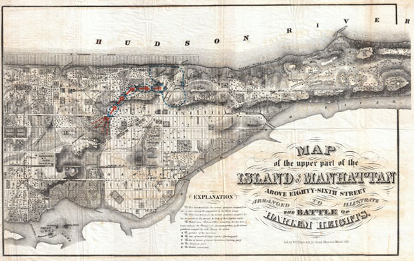
A stunning and rare 1868 Map of the northern part of the island of Manhattan, New York city by W. C. Rogers. Map covers the upper part of Manhattan, above 86th street (including Morningside Heights, Manhattan Valley, Harlem, Inwood, the Upper West Side, the Upper East Side, etc...) in extraordinary detail, depicting streets, buildings, estates and in many cases individual trees. This map is most certainly based upon the 1836 Topographical Map of the City and County of New York drawn by David H. Burr and published by J.H. Colton. Colton's map was perhaps the 'finest example of artistic mapmaking applied to the Island of Manhattan' (I.N. Phelps Stokes). This map uses only the northern portion of Colton's map, but features the same stunning detail. Beautifully hand colored to illustrate the Battle of Harlem Heights. This is the best map of northern Manhattan that we are aware of. Prepared for inclusion in the 1868 edition of Joseph Shannon's Manual Of The Corporation Of The City of New York . An important piece for collectors of New York City cartography.
Cartographer
Joseph Shannon (fl. c. 1850 - 1869) produced a series of New York City almanacs and fact books entitled Manual of the Corporation of The City of New York . Shannon's Manual is very similar to the more common manual issued by Valentine. The production of this annual manual was the responsibility of the Clerk of the Common Council of the City of New York, a position held at different times by both Shannon and Valentine. The manual included facts about the City of New York, city council information, city history, and reported on the progress of public works such as Central Park. More by this mapmaker...
Very good condition. Original folds as issued. Minor verso repairs and reinforcement on folds. Minor age toning, especially on original fold lines. Blank on verso.
Phillips, Philip Lee. A List of Maps of America in the Library of Congress, page 537.