This copy is copyright protected.
Copyright © 2024 Geographicus Rare Antique Maps
1852 Whiteford Map of New Haven, Connecticut (Yale)
NewHaven-whiteford-1852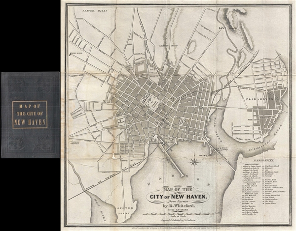

R. Whiteford (fl. c. 1849 – 1856) was a New Haven, Connecticut, based civil engineer and surveyor who was responsible for the 1852 map of the County of New Haven as well as for early town maps of New Haven and Middletown. Although he gives his address as New Haven on the 1852 map, he does not appear in the New Haven city directories. According to Tooley's Dictionary of Mapmakers, Whiteford also contributed to an 1849 map of Burlington County, New Jersey in partnership with J. W. Otley. More by this mapmaker...
Lemuel Swift Punderson (18?? – c. 1903) was a New York City and New Haven, Connecticut, based engraver, author, and publisher. The earliest records suggest Punderson worked in New York from about 1850 to 1855. In 1855 he relocated to New Haven, Connecticut, where he established his own engraving business. A map of New Haven by Punderson dating to 1852, suggest that he had close ties to New Haven even before he relocated there. In 1860 he partnered with Emil Crisand to found Punderson and Crisand, Engravers, Lithographers, and Printers. Punderson also had an interest in antiquities and co-authored the book History of the Antiquities of new Haven, published in 1870. His manuscripts are currently held by the Serling Memorial Library, Yale University, as the 'Lemuel Swift Punderson Papers.' Learn More...
Copyright © 2024 Geographicus Rare Antique Maps | Geographicus Rare Antique Maps
This copy is copyright protected.
Copyright © 2024 Geographicus Rare Antique Maps