This item has been sold, but you can get on the Waitlist to be notified if another example becomes available, or purchase a digital scan.
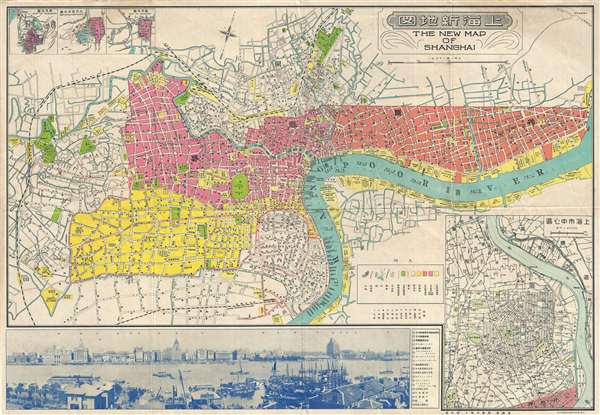
1937 Fusazō Sugie Bi-lingual Map of Shanghai, China (w/ photo of Bund)
NewMapShanghai2-showa12-1937$550.00

Title
The New Map of Shanghai. /上海最新地圖 / Shànghǎi zuìxīn dìtú.
1937 (undated) 21 x 30 in (53.34 x 76.2 cm) 1 : 12000
1937 (undated) 21 x 30 in (53.34 x 76.2 cm) 1 : 12000
Description
This is a rare and attractive bilingual 1937 map of Shanghai, China. It was made around the start of the Second Sino-Japanese war and World War II. Printed by the Japanese in the 12th year of Hirohito's reign, it depicts central Shanghai including the Chinese Quarter, the French Concession, the English Quarter (along the Bund) etc. Shanghai's cosmopolitan International Settlement is highlighted in Orange (USA), Pink (Great Britain), and Yellow (France). Nineteen important buildings along the Bund are carefully noted and can be referenced via a table to the right of the view. These include the first HSBC Bank, the British Club, the Peace Hotel and the Customs House. There is also a lovely vintage panoramic photo of the Bund along the bottom of the map. Of note, the map includes a large inset in the lower right corner illustrating the development of 'Greater Shanghai'.
The Shanghai Bund has dozens of historical buildings, lining the Huangpu River, that once housed numerous banks and trading housing from the United Kingdom, France, United States, Italy, Russia, Germany, Japan, Netherlands and Belgium, as well as the consulates of Russia and Britain, a newspaper, the Shanghai Club and the Masonic Club. The Bund lies north of the old walled city of Shanghai. This was initially a British settlement. A building boom at the end of the 19th century and the beginning of the 20th century led to the Bund becoming a major financial hub of East Asia. The former French Bund, east of the walled city was formerly more a working harbor.
The Bund
The Bund is a waterfront area in central Shanghai. The area centers on the section of Zhongshan Road within the former Shanghai International Settlement, which runs along the western bank of the Huangpu River, facing Pudong, in the eastern part of Huangpu District. The Bund usually refers to the buildings and wharves on this section of the road, as well as some adjacent area. It is one of the most famous tourist destinations in Shanghai and building heights are restricted in this area.The Shanghai Bund has dozens of historical buildings, lining the Huangpu River, that once housed numerous banks and trading housing from the United Kingdom, France, United States, Italy, Russia, Germany, Japan, Netherlands and Belgium, as well as the consulates of Russia and Britain, a newspaper, the Shanghai Club and the Masonic Club. The Bund lies north of the old walled city of Shanghai. This was initially a British settlement. A building boom at the end of the 19th century and the beginning of the 20th century led to the Bund becoming a major financial hub of East Asia. The former French Bund, east of the walled city was formerly more a working harbor.
Shanghai International Settlement
The Shanghai International settlement was created in 1863 when the British and American Shanghai enclaves merged. These concessions had been granted to England and the United States as part of the Unequal Treaties that followed the Opium Wars. From about 1854 the settlements were governed by the Shanghai Municipal Council, a British dominated board of government officials and powerful merchants. The board issued restrictions limiting Chinese habitation on International Settlement territory and oversaw the construction of public services, including Trams, a sewage system, highways, and port buildings. The International settlement expanded several times in the late 19th and early 20th century. It became an enclave of peace and prosperity when the Japanese invaded Shanghai in 1937 but this abruptly came to an end with the Japanese bombing of Pearl Harbor and subsequent invasion of the International Settlement in 1941. After the war the International Settlement lands were returned to Chinese sovereignty.The Greater Shanghai Plan - 大上海计划
An inset in the lower right illustrates part of the Zhabei District (闸北), an area that saw considerable military action in August of 1937, during the Japanese invasion of Shanghai. This part of Shanghai was of interest to the Japanese as the center of new development far from the Concession areas. In 1927, the Chinese Nationalist government conceived of a grandiose plan to build a new Shanghai downriver from the Bund and concession areas - called Greater Shanghai (大上海计划). They hoped Greater Shanghai would diminish the significance of the International Settlement and French Concessions in favor of the new fully Chinese-governed city. Their plan for the new city ironically followed the guidelines laid down in British urban planner Ebenezer Howard's 1902 book Garden Cities of Tomorrow and included broad park-lined avenues, enormous plazas, municipal lakes, and more. It also included a new government center, with imposing buildings surrounded by manicured gardens.The Shanghai-Hengshen Company Development
When the Japanese invaded Shanghai in 1937, they coopted the vision of Greater Shanghai, but put their own stamp on it with a new plan partially derived from the original. This they termed the 'Greater Shanghai Metropolitan Plan' (' 上海大都市计划). Development rights fell to the newly minted Japanese joint-stock company Shanghai-Hengshen Ltd. (上海恒產股份有限公司 / 恒产株式会社). The firm used war plunder to capitalize its development and construction operations. They brought in hundreds of Japanese immigrants to manage the Greater Shanghai construction project, constructing more than 100 garden houses in Wujiaochang (literally 'five corner plaza'). Development of the new city proceeded on-and-off throughout the war but ended in 1945, when the Japanese were fully driven from Shanghai. Following the war, governance of the concessions reverted to Chinese authorities, negating the original purpose for Greater Shanghai. Although Shanghai did ultimately expand into these areas, the grand vision was replaced by more organic growth.Publication History and Census
There are multiple maps of the same name and lineage, and least two editions of this specific map. The first was issued in 1933. That edition features statistical tables in the upper left, inset maps in the lower right of Nanking (Nanjing), Hanchow Shiwoo (Hangzhou), and Soochow (Suzhou), as well as a map of the course of the Yangtze River. A second edition appeared in 1937, after the Japanese invasion of Shanghai. That example moves the three inset city maps to the upper left corner, replacing the statistical table. In the lower right, the Yangtze River Map is replaced with a map of Greater Shanghai, a development area roughly corresponding to the Zhabei District (闸北). The photo of the Bund has also been revised, most notably, the later edition features the Shanghai/Broadway Mansions, constructed in 1934. Today all examples have become quite rare.Cartographer
Fusazō Sugie (杉江房造; fl. c. 1910 – 1950) was a Japanese bookseller, printer, and active in Shanghai during the final years of the Qing. Fusazō was the owner of the Nihon-do Japanese Bookstore (日本堂書店) in Shanghai, located at 155 Hong-Kou-Wen Street and 237 Woosung Road. He issued numerous guidebooks, souvenir photo books, and maps associated with Shanghai and Nanjing, many of which were bilingual and marketed to American and European tourists and servicemen. His bilingual New Map of Shanghai, published in various states and editions from 1931 well into the 1940s, is his most notable cartographic work. More by this mapmaker...
Condition
Very good. Minor wear and toning along original fold lines. Backed on archival tissue.