This item has been sold, but you can get on the Waitlist to be notified if another example becomes available, or purchase a digital scan.
1872 Beers Map of Newark, New Jersey
Newark-beers-1872$112.50

Title
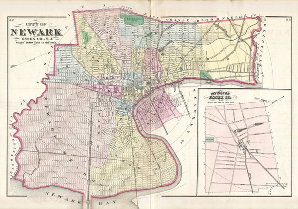
City of Newark Essex Co., N.J.
1872 (undated) 15.15 x 22 in (38.481 x 55.88 cm)
1872 (undated) 15.15 x 22 in (38.481 x 55.88 cm)
Description
A fine example of the 1872 map of Newark, New Jersey by F. W. Beers. Covers the center of Newark from Elizabeth to Belleville and from Bloomfield to Newark Bay and the Passaic River. Shows streets, city wards, canals, parks, railways, and important buildings. Includes the 'Proposed New York and Newark Bay Ship Canal,' which though the darling of several New Jersey politicians of the period, never materialized. Concentric circles marking mileage radiate out from the center of the city at the intersection of Market and Broad Streets. Also includes adjacent East Newark. An inset map in the lower right quadrant details Irvington, Essex, Co. Published form original survey's by F. W. Beers in his 1872 Atlas of New Jersey.
Cartographer
The Beers family (Fredrick, Silas, James and Daniel) (fl. c. 1850 - 1886), along with Charles and Augustus Warner, were prominent map publishers working from the 1850s to the late 1880s. Often publishing under the Warner & Beers designation, the combined firms produced a series of important state and county atlases and map of much of the northeastern United States. Many of their regional maps are among the most detailed and well laid out maps ever produced of their respective regions. Because Warner & Beers county maps were often detailed down to the individual homes and landowners, they have become highly sought after by general and family historians. In additional to producing maps of surpassing detail, Warner & Beers also maintained an earlier generation's attention to detail and quality while publishing in an era ever increasingly dominated by the low cost printing methods used by the publishing empires of Rand McNally and George Cram. More by this mapmaker...
Source
Beers, F. W., State atlas of New Jersey based on State Geological Survey and from additional surveys by and under the direction of F.W. Beers, 1872.
Condition
Very good condition. Original centerfold. Map of Plainfield, NJ, on verso.
References
Rumsey 1573.014.