This item has been sold, but you can get on the Waitlist to be notified if another example becomes available, or purchase a digital scan.
1661 Cluver Map of the World in Hemispheres Korea and (California as an Islands)
OrbisTerrarumTypus-cluver-1661$162.50

Title
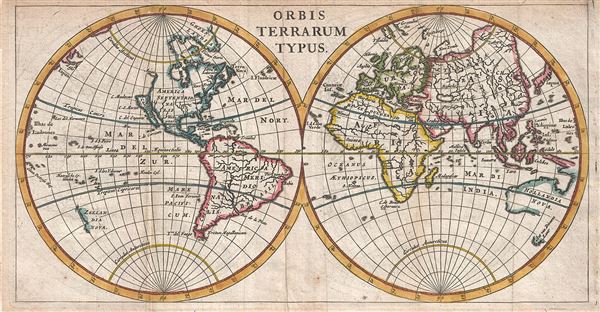
Orbis Terrarum Typus.
1661 (undated) 5 x 9.5 in (12.7 x 24.13 cm) 1 : 170000000
1661 (undated) 5 x 9.5 in (12.7 x 24.13 cm) 1 : 170000000
Description
A scarce and attractive 1661 miniature map of the world by Philipp Cluver. Cluver presented the world according to the geographical conventions of the time with California and Korea appearing in insular form. In South America, Lake Parima, mythical site of El Dorado according to Sir Walter Raleigh, is shown but not textually identified. In Asia, the Caspian Sea is erroneously rendered on a north-south axis. The Nile follows the Ptolemaic Two Lakes Theory but curiously connects to the various rivers of the Congo. The coast lines of Australia (Hollandia Nova), Tasmania (Van Diemens Lant) and New Zealand (Zeelandia Nova) are only partially filled in giving evidence to extremely limited reconnaissance available with regard to the South Pacific. This map was issued for the 1661 edition of Cluver's Introductionis in Uniersam Geographiam.
Cartographer
Philipp Clüver (also Klüwer, Cluwer, or Cluvier, Latinized as Philippus Cluverius and Philippi Cluverii) (1580 - December 31, 1622) was a German geographer and historian active in Leiden in the late 16th and early 17th centuries. Clüver was born in the Royal Prussian city of Danzig (Gdansk), then a province of the Kingdom of Poland. He study of law at the University of Leiden before turning his attention to history and geography. Cluver traveled, mostly by foot, extensively throughout Europe, spending time in Germany, England, Scotland, Holland and Italy. On returning to Leiden he was given a special appointment as geographer and put in charge of the university's library. Cluver is best known for his general study of the geography of antiquity. A popular Enlightenment era field of study, antiquarian geography attempted to resolve place names known from classical literature but, by the time of the Renaissance, geographically confused. Cluver based his research not only on classical literary sources, but — and this was his primary contribution to the genre — also his extensive and local inspections of sites. Today he is considered one of the founding fathers of historical geography. Cartographically Cluver's most prominent works include his edition of Ptolemy's Geographia (based on Mercator's edition of 1578) and for miniature atlases that were reprinted for most of the 17thand 18th centuries. Cluver was also known as Klüwer, Cluwer, or Cluvier, Latinized as Philippus Cluverius and Philippi Cluverii. He died in Leiden in 1622. More by this mapmaker...
Source
Cluver, P., Introductionis in Universam Geographiam tam veterem quam novam Libri VI, (Amsterdam) 1661.
Condition
Very good. Original fold lines. Original platemark visible. Some transference. Blank on verso.
References
Shirley, Rodney W., The Mapping of the World: Early Printed World Maps 1472-1700, no. 407, page 431.