This item has been sold, but you can get on the Waitlist to be notified if another example becomes available, or purchase a digital scan.
1881 Adams Monumental Illustrated Panorama of History
PanoramaofHistory-adams-1881$1,500.00

Title
Adams' Illustrated Panorama of History.
1881 (dated) 27 x 271 in (68.58 x 688.34 cm)
1881 (dated) 27 x 271 in (68.58 x 688.34 cm)
Description
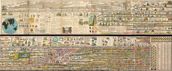
A truly monumental achievement, this is Adams' Illustrated Panorama of History. Measuring some 27 inches high and 271 inches long, this gigantic panoramic diagram charts the history of the world from a Biblical perspective, starting with the creation of Adam in 4004 B.C. and ending in 1881 (though projected into the future as far as 1900). Adams centers his chart on the 'Stream of Time' which is divided into decades and centuries. Initially he simply follows the Bible's 'begats,' but eventually he slowly segues into the historical period with the development of egyptian, Persian, and Greek culture. He notes all important events and offers historical and Biblical commentary where appropriate - often illustrating historical monuments and Biblical events and monstrosities. eventually the map gets necessarily more and more complicated as it passes into the classical era, the pre modern era, and ultimately modern times. At the end of the chart Adams shows the currently reigning world rulers, discusses the development of the United States, and even offers a breakdown of historically important technological developments. Adams' also interestingly attempts to reconcile Biblical with global history, associating for example, Noah, with 'Yao,' a legendary figure in early Chinese mythology. This chart is so rich in detail and information that it is all but impossible to fully give it credit here, however, we encourage you to use the zoom engine above to thoroughly appreciate this remarkable document.
Adams' chart enjoyed a long print run in numerous editions with at least 2000 copies being printed in the United States alone. The chart was also enormously popular in europe where the London Illustrated News included it in their 'Notes of the Week':
This amazing chart was drawn by Sebastian C. Adams of Salem, Oregon. The present example is the scarce British edition published in 1881, with an updated 'modern era' section and breakdown of world rulers. The chart was published by A. H. Walker, a prominent european publisher with offices in London and Paris. This example is accompanied by its original linen binder as well as a supplementary volume published by Page and Pratt of London further annotating the chart. extremely rare.
Adams' chart enjoyed a long print run in numerous editions with at least 2000 copies being printed in the United States alone. The chart was also enormously popular in europe where the London Illustrated News included it in their 'Notes of the Week':
Imagine Haydn's 'Dictionary of Dates,' plus Calmet's 'Dictionary of the Bible' plus the 'Complete Gazetteer' plus all Maunder's 'Treasuries' made graphic, and you gather some idea of this stupendous pictorial roll which seems to have been suggested by the ancient picture writings of the Mexicans.This and numerous other popular reviews in europe inspired requests for the chart from dignitaries including as the Queen of Denmark and the Crown Prince of Naples.
This amazing chart was drawn by Sebastian C. Adams of Salem, Oregon. The present example is the scarce British edition published in 1881, with an updated 'modern era' section and breakdown of world rulers. The chart was published by A. H. Walker, a prominent european publisher with offices in London and Paris. This example is accompanied by its original linen binder as well as a supplementary volume published by Page and Pratt of London further annotating the chart. extremely rare.
Cartographer
Sebastian C. Adams (1825 - 1898) was an American school teacher and surveyor active in Oregon and California in the mid to late 19th century. Adams was born in Sandusky, Ohio and lived for a time in Galesburg, Illinois before attending Knox College. In college he found that he had a gift for teaching and abandoned his academic career to become a private tutor and school teacher. Seeing a bright future in the American West, Adams traveled to California via the Oregon Trail. Though nearly perishing en route, Adams survived to take a land grant in Yamhill Country, Oregon. An ardent Christian, Adams founded a Christian college that, though it failed due to lack of funds, was ultimately incorporated into Bethel College. Later he worked as a surveyor, a preacher, a county clerk, and as Oregon State Senator. In 1871 he published his Illustrated Panorama of World History, a remarkable document that attempts to synchronize Biblical history with global historic elements. The chart was an incredible success and has proven his greatest legacy. Adams died in 1898 with the cause of death being cited as "la grippe". More by this mapmaker...
Condition
Very good condition. A single massive panoramic mounted on linen in 21 panels. Some panels exhibit a bit of chipping here and there as well as edgewear, otherwise this is a remarkably clean example. Comes with original boards, which are detached form the panorama but intact. The image above breaks the chart down into two sections for readability, however, it is in fact a single document roughly 22 feet long. In the photo above, the upper section covers history roughly from the creation of man to the construction of Solomon's Temple, the lower section covers from the Great Pyramid to 1900 (Adams takes some liberties with the future).