
This item below is out of stock, but another example (left) is available. To view the available item, click "Details."
Details
1930s Joseph Pinchon Watercolor Map of Paris, 1st and 2nd arrondissements.
1931 (undated) $9,500.00
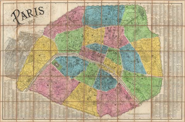
1867 Dumas Vorzet Folding Map of Paris, France
Paris-dumasvorzet-1867$375.00

Title
Paris.
1867 (dated) 29.5 x 45 in (74.93 x 114.3 cm) 1 : 12800
1867 (dated) 29.5 x 45 in (74.93 x 114.3 cm) 1 : 12800
Description
A dramatic and highly decorative 1867 linen backed case or pocket map of Paris France by Edouard Dumas-Vorzet. Centered on the Seine, this map covers embastilled Paris as contained by the Thiers Wall as well as its immediate vicinity, including the Bois de Boulogne and Bois de Vincennes. Dumas-Vorzet drew this map to illustrate Napoleon III and Georges-Eugène Haussmann's revolutionary modernization of Paris. Known in French as the Grands Travaux, Haussmann's redesign of Paris defined it as a modern city, with narrow alleyways and confusing streets replaced by a broad network of grand boulevards, imposing facades, parks, and monuments. The cartographer also highlights the 1860 repartitioning of the arrondissement system into 20 distinct zones. All major streets, monuments, important buildings, rail lines, parks, and plazas are illustrated. The map proper is surrounded by an extensive street index presented in tabular format. Dumas-Vorzet has also incorporated a dramatic floral themed title cartouche in the upper right quadrant that significantly enhances the overall beauty of this piece.
Condition
Very good. Dissected and mounted on linen in 55 sections. Original linen backing has been reinforced with archival tissue.
References
Harvard, Pusey Library, Hollis Id: 010890135. Vallee, Leon, Catalogue des plans de Paris et des cartes de l'ile de France, (Bibliotheque Nacionale), (Ge C 3699) 3145.