This item has been sold, but you can get on the Waitlist to be notified if another example becomes available, or purchase a digital scan.
1878 Gaultier Pocket Map of Paris, France
Paris-gaultier-1878$200.00

Title
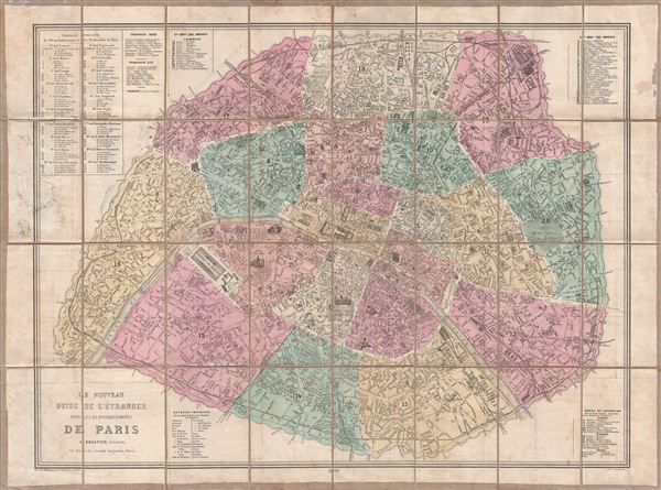
Le Nouveau Guide de l'Etranger Dans les 20 Arrondissements de Paris.
1878 (dated) 22.5 x 30.5 in (57.15 x 77.47 cm)
1878 (dated) 22.5 x 30.5 in (57.15 x 77.47 cm)
Description
A fine 1878 map of Paris designed by J. Gaultier to capitalizes on international tourism associated with the 1878 exposition Universelle. Centered on the Seine River, this map details the embastilled center of Paris from the Pte. D'Auteuil to the Porte de Vincennes. Pairs is here divided into 20 Arrondissments. Monuments and other important buildings are represented pictorially - a graphic style that developed in Paris in the 1850s. The map names all streets, gardens, public squares, monuments, and important buildings, as well as tramways, rail lines, and bridges. Tabular data describes the routes of special ferries planned for the exposition, as well as buses, and trams. A variant of this map was also issued to illustrate the exposition Universelle Album Guide; however, the present example seems to be a standalone edition.
The 1878 exposition Universelle was the third Paris World's Fair intended to celebrate Frances dramatic recovery following the 1879 Franco-Prussian War. At the time, it was the largest trade fair ever held, covering more than 66 acres of land around the Champs de Mars, where the eiffel Tower stands today. It was this fair that first showcased the completed head of the Statue of Liberty.
The 1878 exposition Universelle was the third Paris World's Fair intended to celebrate Frances dramatic recovery following the 1879 Franco-Prussian War. At the time, it was the largest trade fair ever held, covering more than 66 acres of land around the Champs de Mars, where the eiffel Tower stands today. It was this fair that first showcased the completed head of the Statue of Liberty.
Condition
Good. Some soiling. Dissected and mounted on linen in 28 sections. Original linen backing stable.
References
Vallee, Leon, Catalogue des plans de Paris et des cartes de l'ile de France, (Bibliotheque Nacionale) 1324.