This item has been sold, but you can get on the Waitlist to be notified if another example becomes available, or purchase a digital scan.
1744 Harris Map of Beijing or Peking, China
PekingBeijing-harris-1744$625.00

Title
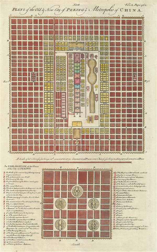
Plans of the Old & New City of Peking Metropolis of China.
1744 (undated) 14 x 9 in (35.56 x 22.86 cm) 1 : 27300
1744 (undated) 14 x 9 in (35.56 x 22.86 cm) 1 : 27300
Description
An uncommon and appealing 1744 map of Beijing or Peking, China. The map features two maps of Beijing both drawn to scale. The larger upper map illustrates 'New Peking' c. 1700 while the smaller map shows ancient Beijing. Both maps feature numerous numbered and/or lettered sites corresponding to a key in the lower quadrants. The key identifies such sites as the 'Portal of Heaven,' the 'Hall Thrice Exalted,' the 'House which received Heaven,' and many others. The map was mostly likely engraved by Bowen to illustrate John Campbell's 1744 posthumous publication of John Harris' collection of Collection of Voyages and Travels. The engraved map offered here is most likely the work of Emmanuel Bowen, who produced most of the maps of Harris' work.
CartographerS
John Harris (c. 1666 – 7 September 1719) was an English writer, scientist, and Anglican priest. He is best known as the editor of the Lexicon Technicum: Or, A Universal English Dictionary of Arts and Sciences (1704), the earliest of English encyclopedias; as the compiler of the Collection of Voyages and Travels, published posthumously under his name by John Campbell; and as the author of an unfinished county history of Kent. Harris was born in Shropshire England and studied at Trinity College, Oxford. In 1696 he was elected a Fellow of the Royal Society, of which he briefly served as vice-president. He unfortunately died in poverty due to fiscal mismanagement. More by this mapmaker...
Emanuel Bowen (1694 - May 8, 1767) had the high distinction to be named Royal Mapmaker to both to King George II of England and Louis XV of France. Bowen was born in Talley, Carmarthen, Wales, to a distinguished but not noble family. He apprenticed to Charles Price, Merchant Taylor, from 1709. He was admitted to the Merchant Taylors Livery Company on October 3, 1716, but had been active in London from about 1714. A early as 1726 he was noted as one of the leading London engravers. Bowen is highly regarded for producing some of the largest, most detailed, most accurate and most attractive maps of his era. He is known to have worked with most British cartographic figures of the period including Herman Moll and John Owen. Among his multiple apprentices, the most notable were Thomas Kitchin, Thomas Jeffreys, and John Lodge. Another apprentice, John Oakman (1748 - 1793) who had an affair with and eventually married, Bowen's daughter. Other Bowen apprentices include Thomas Buss, John Pryer, Samuel Lyne, his son Thomas Bowen, and William Fowler. Despite achieving peer respect, renown, and royal patronage, Bowen, like many cartographers, died in poverty. Upon Emanuel Bowen's death, his cartographic work was taken over by his son, Thomas Bowen (1733 - 1790) who also died in poverty. Learn More...
Source
Harris, J., Navigantium atque Itinerantium Bibliotheca, or Complete Collection of Voyages and Travels (London) 1744.
Condition
Very good. Blank on verso. Platemark.